Cala del Senyor Ramon belongs to the municipality of Santa Cristina d’Aro. It is eleven kilometres from Santa Cristina d’Aro, with a mountain ridge in between, and no road connects the two directly. To reach this town’s own beach you drive out of the municipality altogether and come back in along the coast road from Sant Feliu de Guíxols or Tossa de Mar. It is one of the odder pieces of geography on the Costa Brava, and it explains almost everything about what this beach is and is not.
A Town That Cannot Reach Its Own Coast
The hills that close the Vall d’Aro to the south run all the way down to the sea, and they cut the municipality in two. On the inland side sits the town: the town hall, the shops, the population. On the seaward side sit its beaches — Cala Canyet, Platja del Canyet and Cala del Senyor Ramon — reachable only from the winding GI-682 corniche that belongs, in every practical sense, to the two towns on either end of it.
The consequence is a beach with no town behind it. There is no promenade at Senyor Ramon, no seafront apartments, no municipal beach bar, no bus stop, no lifeguard, no showers, no shop. Not because anyone protected it, and not because it is remote in absolute terms — it is a twenty-minute drive from a supermarket — but because the settlement that would normally grow behind a beach of this size is on the wrong side of a mountain.
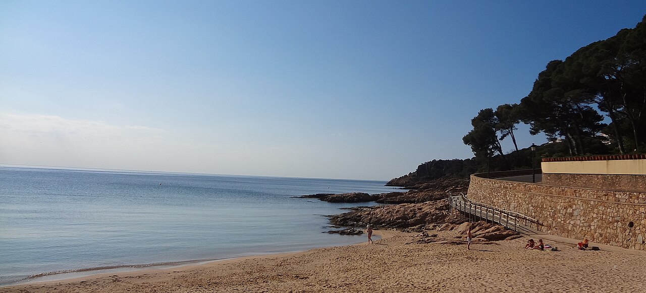
Drive fifteen minutes north along the same road and you can see the alternative. Platja de Sant Pol, at Sant Feliu de Guíxols — the beach in the photograph at the top of this page — is a beach that did get its town: 880 metres of sand, a promenade of noucentista mansions, Blue Flag, showers, chiringuitos, an adapted access chair and free parking five minutes from the centre. Same coast, same rock, same water — and a completely different day out, because a settlement grew behind it instead of a mountain standing there.
What that means in practice at Senyor Ramon is simple and worth taking seriously: everything you will want during the day, you carry down. And the day ends with carrying whatever is left back up.
What the Beach Is Like
First, a figure worth correcting, because it has been copied across the internet for over a decade. You will read that Senyor Ramon is an 800-metre beach. The Catalan tourism authorities and the regional beach registers put it at around 330 to 350 metres, and that is the figure to plan around. It is still large for this coast — one of the biggest sandy stretches between Sant Feliu de Guíxols and Tossa de Mar — but it is not a kilometre of empty sand, and arriving expecting one is how a good beach disappoints people.
The sand is coarse and golden, roughly fifty metres deep, and the seabed offshore is sand rather than rock or weed — which is exactly why the water here reads as clean turquoise rather than the darker green of a posidonia cove. The entry shelves steeply, so this is not a wade-out-forever beach and small children need watching.
What gives the place its character is the enclosure. Cliffs rise behind and around it, and the official regional advice is to sunbathe well away from their base because of rockfall risk. That is not boilerplate on a cove like this one, where nobody clears loose rock and nobody is watching. Pick your spot out on the open sand.
To the north, the Escollos de Canyet — a scatter of islets and reef — separate Senyor Ramon from Cala Canyet, and they are the best snorkelling and diving on this stretch: structure, clear water and no boat traffic to speak of. To the south, cliffs lead to the tiny Caleta dels Concagats and then to Cala Vallpresona.
On the question people actually ask: Senyor Ramon is customarily used by nudists at the quieter end, but it is not a designated naturist beach. Vallpresona, a little further south, is the one with that reputation formally. In practice the occupancy here is low enough that nobody is crowding anybody, and the sensible approach is the usual one — look where you are putting your towel down and let other people get on with their afternoon.
Getting Down There
By Car, and Then on Foot
Take the GI-682 between Sant Feliu de Guíxols and Tossa de Mar and watch for the roadside sign somewhere between kilometre 32 and 35 — the exact marker quoted varies by source, so slow down and look rather than trusting an odometer. From the road the descent crosses private land, and in season you pay a fee at the top to leave the car there. It is not a municipal car park and there is no free alternative worth the walk.
From there it is a switchbacking path down to the sand, maintained, with wooden walkway sections in places and genuinely good views on the way. Going down is easy. Coming up at the end of a hot day with a cool bag is the part people underestimate, and it is the single biggest reason to think about what you pack.
A second path starts from the Rosamar residential development, which is useful if you are staying nearby.
By Boat
Anchoring off is a popular option and it removes both the fee and the climb. It is also the sane way to see the neighbouring coves: the coastal scramble between Senyor Ramon, Concagats and Canyet crosses exposed rock with no protection, and a kayak or small boat does the same trip without the risk.
By Public Transport
There is none. No bus stops at the top of the path. This is a beach you need a car, a motorbike or a boat to reach.
Map
The Other Half of the Municipality
If the ridge is what separates this beach from its town, it is worth crossing it, because the inland half of Santa Cristina d’Aro is more interesting than the beach.
Up at Romanyà de la Selva stands the Cova d’en Daina, which the Generalitat calls one of the most complete and best preserved megaliths in Catalonia. It is dated to between 2700 and 2200 BC, and it is a particular kind of tomb: a sepulcre de galeria catalana, or broad-corridor grave, in which the passage is almost as wide as the chamber it leads to — a late Neolithic development out of the earlier passage graves. What survives is a U-shaped covered gallery some seven metres long, built of granite slabs, still ringed by much of its original tumulus and by a cromlech of standing stones.
It was found in the early 1900s by Manuel Cazurro, a natural history teacher at the Institut de Girona, on land belonging to the Cama family. Lluís Esteva i Cruañas excavated it in 1957 and turned up bone, teeth, flint arrowheads, pottery and small ornaments — the residue of collective burials made here across generations. There is a parking area on the road and a path of a hundred and fifty metres or so through the holm oaks. It takes ten minutes to walk round and it is thousands of years older than everything else on this coastline.
A few metres away is the small cemetery of Romanyà, where Mercè Rodoreda is buried. Rodoreda — the author of La plaça del Diamant, and by common consent the most important Catalan novelist of the twentieth century — spent her last years in this village, wrote here, and drew on the place in her work. There is a signposted literary itinerary linking the sites associated with her.
The two are not really separate sights. Rodoreda walked up to the dolmen often, and she left a piece of writing about it that is held to be one of the finest things written in Catalan about a megalithic monument. The cemetery is a few minutes down the same road from the parking area. If you go, do them together and in that order.
A dolmen, a novelist’s grave and an unserviced beach, all in one municipality, with a mountain in the middle so that you cannot easily do them on the same trip. That is Santa Cristina d’Aro.
Eating and Sleeping Nearby
Nothing on the sand, and nothing worth calling a village at the top of the path. Bring food and, above all, water: there is no tap at the bottom.
For a real meal it is Sant Feliu de Guíxols or Tossa de Mar, in either direction along the corniche, both with proper restaurant scenes — this is suquet de peix country, and in autumn the inland Gavarres hills put wild mushrooms on every menu in the area. Santa Cristina d’Aro town itself is the quiet, cheaper option and pairs naturally with the dolmen rather than with the beach.
There is no accommodation at the cove. Most people base themselves in Tossa or Sant Feliu; for a fuller-service beach day on the same trip, Platja Sa Conca at Castell-Platja d’Aro is the opposite end of the spectrum and a short drive north.
When to Go
The limiting factor at Senyor Ramon is not the sea, the wind or the crowd. It is the climb back up, and the fact that there is no water at the bottom. That reframes the calendar: a beach with no shade, no tap and a switchback ascent is a beach that punishes you for coming in the middle of a heatwave, and rewards you in June, September and October when you can walk out at four in the afternoon without suffering for it.
September is the pick. The sea is at its warmest of the year, the parking fee is easier to justify because the path is quiet, and the walk up is merely a walk. July and August work if you arrive early and leave early — before the sun is on the cliff face — and if you carry more water than you think you need.
Out of season this is a walk rather than a swim, and a good one, though the parking arrangement may not be operating. For how this cove compares with the rest of the region, see our Costa Brava beach rankings.
Practical Tips
- Carry more water than you plan to drink. There is no tap, no bar and no shade, and the exit is uphill.
- Take cash for the parking. It is a private arrangement on private land, not a municipal machine.
- Sit away from the cliffs. Rockfall is the one real hazard here and nobody is monitoring the face.
- Bring a mask for the Escollos de Canyet. The reef at the north end is the best thing in the water on this stretch.
- Do not scramble to the neighbouring coves. The rock sections are exposed and unprotected; go by kayak or not at all.
Frequently Asked Questions
How long is Cala del Senyor Ramon really?
Around 330 to 350 metres, according to Catalan tourism sources and the regional beach listings. The 800-metre figure carried by many sites is not one we have found in any register, and it has the look of a number copied from page to page rather than measured. We say so rather than repeat it, but we cannot tell you where it started.
How do you get there?
By car along the GI-682 between Sant Feliu de Guíxols and Tossa de Mar, then down a steep switchback path from a paid private parking area at the top. There is no public transport.
Is it a nudist beach?
It is used by nudists at the quieter end but is not an officially designated naturist beach. Nearby Cala Vallpresona is the one better known for that.
Are there any services?
None at all — no lifeguard, no toilets, no showers, no bar, no drinking water. Everything comes down the path with you.
Written for general information, not as travel, legal or safety advice. Cala del Senyor Ramon has no lifeguard, no drinking water and no facilities of any kind, the entry into the sea shelves steeply, and the surrounding cliffs carry a documented rockfall risk — stay well clear of their base. Access crosses private land and the parking arrangement, its fee and its opening season are set by the owner and can change or cease without notice. The coastal scramble to neighbouring coves is unprotected. Confirm current details with the Ajuntament de Santa Cristina d’Aro before travelling.
Sources
Checked on 27 August 2026.
- The Cova d’en Daina. Generalitat de Catalunya, Patrimoni Cultural — Cova d’en Daina. Source for the dating of 2700 to 2200 BC, for the classification as a sepulcre de galeria catalana or broad-corridor grave and its place in the late Neolithic sequence, for the seven-metre U-shaped covered gallery of granite slabs, and for the original circular tumulus and cromlech. The discovery by Manuel Cazurro in the early 1900s and the 1957 excavation by Lluís Esteva i Cruañas are recorded in the standard accounts of the monument.
- A protection status we could not pin down. One account records the dolmen as declared a national historic monument in 1931, among the first such distinctions given to a Catalan megalith; another catalogues it today as a bé cultural d’interès local in the archaeological-zone category. Those are different tiers and we have not reconciled them, so the guide describes what the monument is rather than what it is filed as.
- The length of the beach. The 330 to 350 metre figure comes from Catalan tourism sources and regional beach listings; the national register is the Guía de Playas of the Ministerio para la Transición Ecológica y el Reto Demográfico (Fuente: © Ministerio para la Transición Ecológica y el Reto Demográfico). We have not located the 800-metre figure in any register and do not know its origin. We are not going to guess at it, and we mention the discrepancy because a reader who has seen the larger number elsewhere deserves to know why ours is different.
- Access and the parking fee. The descent crosses private land and the charge at the top is a private arrangement, not a municipal one. Nothing about it is published in a form we can link to; it is set by the landowner and can change or cease. The public right to be on the sand itself is unaffected by any of that: the beach is maritime-terrestrial public domain under the Ley 22/1988 de Costas, whose article 31.1 makes its use free and open to all. What is being charged for is the parking and the crossing, not the beach.
- Rockfall. The warning to stay clear of the cliff base reflects standing regional advice for unserviced cliff-backed coves. There is no monitoring of the face here and no lifeguard to move anyone on, which is precisely why it is worth repeating rather than filing as boilerplate. The same absence has a second consequence people rarely think about: with no lifeguard there is no flag either, and an empty pole carries none of the information the national warning-flag system is designed to give you.
- Still unverified. The kilometre marker on the GI-682 at which the sign appears, which is quoted differently by different sources — hence the instruction to slow down and look; the naturist custom at the quieter end and the reputation of Cala Vallpresona, neither of which carries any official designation; and the second path from the Rosamar development.
- The Blue Flag. Where this guide refers to Blue Flag status, the award is administered in Spain by ADEAC, which publishes the list of awarded beaches (PDF). It is a voluntary certification a town hall applies for rather than a public designation, it measures municipal management rather than natural water quality, and the 2026 round runs for two years rather than one. Our guide to what the award measures sets out why several of the best coves in these guides do not have one.
Image Credits
A note on the photography: there is no freely licensed photograph of Cala del Senyor Ramon in the public image archives, which is itself a fair measure of how little visited this beach is. Rather than pass off another cove as this one, the header image shows Platja de Sant Pol at Sant Feliu de Guíxols, further north on the same coast road, and is labelled as such.
- Header image: Platja de Sant Pol by Isidro Jabato, licensed under CC BY-SA 4.0, via Wikimedia Commons. This photograph shows Platja de Sant Pol (Sant Feliu de Guíxols), not Cala del Senyor Ramon.
Leave a Reply