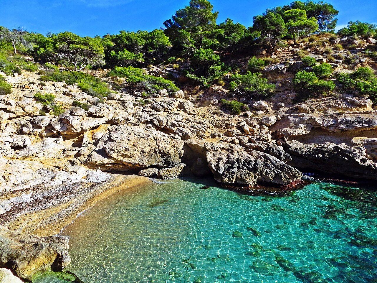
There is a sign at this cove, put up by the town council, that reads “Al Racó, millor en conill, naturalment” — roughly, at Racó, better in the nude, naturally. It is a pun: en conill is Valencian slang for naked, and conill also means rabbit, which is what the cove is named after. Few Spanish municipalities have ever signposted a beach quite so cheerfully.
That sign is also the best way to understand what has happened here over the last decade. Racó del Conill has been a naturist cove since the 1970s. Then it went viral, and a beach barely 100 metres long started receiving the kind of crowds a beach ten times its size would struggle with.
Where Is Racó del Conill?
On the northern coastline of Villajoyosa (La Vila Joiosa), province of Alicante, roughly 3 to 5 kilometres from the town centre on the road toward Benidorm. This is the cliff-and-cove stretch of the Marina Baixa, and it looks nothing like the long developed beaches south of town, including Playa Paraíso.
It sits near the boundary with El Campello and within easy reach of Benidorm and Cala de Finestrat, which is why it tends to get folded into a day of cove-hopping rather than visited on its own.
What the Cove Is Actually Like
Small. Published figures run from 80 to 160 metres, and the spread comes down to where each one stops measuring, and just a few metres wide in most places. A rocky outcrop divides it into two uneven sections, which makes it feel more sheltered and more layered than the dimensions suggest.
The shore alternates between smooth pebbles, bare rock, and occasional patches of sand — water shoes, not sandals. What it trades away in comfort it returns in clarity: the water here is genuinely turquoise, and the pine-covered cliffs around it give a sense of being somewhere undeveloped, which on this particular stretch of the Costa Blanca is increasingly hard to find.
There is no Blue Flag, no lifeguard, no showers, and no restrooms. There is also no flagpole, which is worth understanding before you swim: an empty pole is not a green flag, and on unsupervised coves like this one the beach warning flag system simply does not operate. A seasonal kiosk operates at the cove, and opinion on it is genuinely divided: convenient if you forgot water, though longer-standing visitors point out that music and a bar have changed a place whose whole appeal was that it had neither.
The Naturist Tradition, and What Became of It
Racó del Conill has been naturist since the 1970s, and unusually, that status is not merely tolerated but formally backed: the Ayuntamiento de Villajoyosa has signposted the cove under its municipal beach regulations, which is the origin of the sign at the top of this page.
In practice, the cove’s social media fame has brought a large share of clothed visitors, and today both share the same very small stretch of shoreline. Neither is wrong and nobody polices it, but it is worth knowing before you arrive rather than discovering it on the way down the path. Whichever you choose, the etiquette is the same one that has always applied at naturist beaches: no photographing other people.
If you want the same thing closer to Alicante city, Cala Cantalar is the low-key alternative on the Cabo de las Huertas.
In the Water
Snorkelling is the main reason to get in. Clear water and rocky ground around the central outcrop make for good visibility close to shore. Bring your own mask — there is no rental of anything here, which also applies to paddleboards and kayaks, though the generally calm water suits both if you arrive with your own.
The rock formation splitting the cove is used for jumping into the water, and it is worth being blunt about it: there is no lifeguard, no phone signal guarantee, and depth varies with the season as sediment shifts. People who jump here know the spot. Watching first, and checking depth yourself, is not excessive caution.
The Coastal Path to the Torre del Aguiló
The Colada de la Costa links Racó del Conill with Playa del Torres at one end and the Torre del Aguiló at the other. Its name is not decorative: a colada is a legal category. Spain’s vías pecuarias are the network of routes along which livestock was moved between summer and winter pasture, and they are classified by width — cañadas the widest, then cordeles, then veredas, with coladas the narrowest. Shepherds brought flocks down this one from the mountains of l’Alcoià to winter on a warmer coast. Villajoyosa recovered the route some years ago and turned it into the footpath you walk today, and it has since been awarded Sendero Azul status by the same organisation that runs the Blue Flag programme.
That legal status is the reason the path exists at all on a coastline where almost everything else has been built on. Drovers’ roads are public domain, and public domain of a kind that cannot be sold, cannot be acquired by long use and cannot be seized for debt — the same category of protection the shoreline itself enjoys. A strip of undeveloped Alicante coast survives here because livestock had a right of way over it.
There is a monument at each end. The Torre del Aguiló, at the high point of the route, is a sixteenth-century watchtower built under Felipe II as part of the same anti-piracy network that produced the towers at Moraira, Granadella and the Mascarat further north. At the Playa del Torres end stands something rarer: the Torre de Sant Josep, also called the Torre de Hércules, a Roman funerary tower raised in the middle of the second century AD as the tomb of a citizen of Allon, as Villajoyosa was then called. It is held to be the largest surviving Roman funerary tower on the Iberian Peninsula, it was declared a Bien de Interés Cultural in 1990, and the Generalitat restored it in 2014. Most people walking this path for the cove never register that it starts at a Roman tomb.
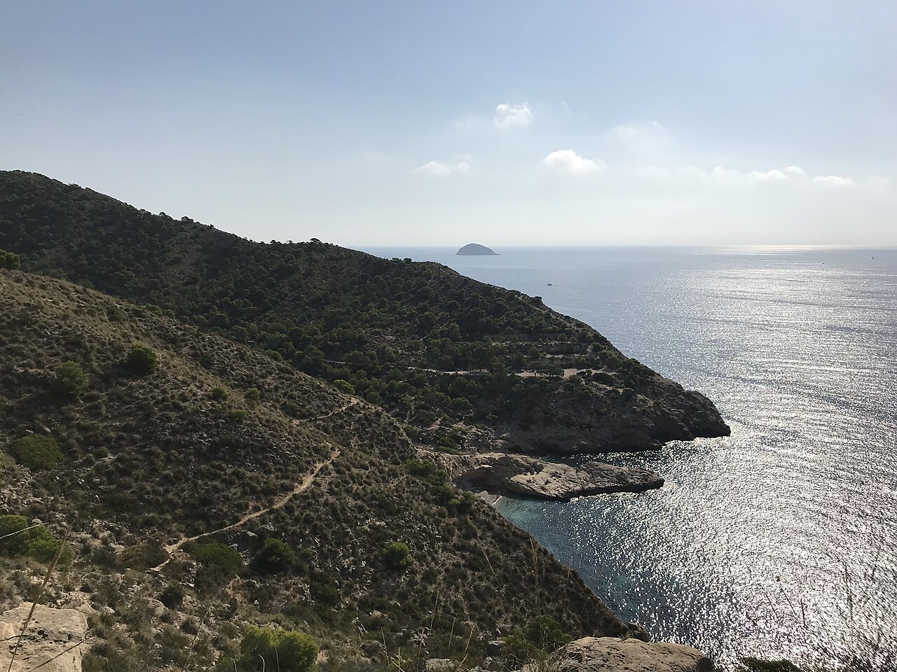
It is the best thing to do here on a day when the cove is full, and it gives the cliffside views that no amount of time on the pebbles will.
One curiosity while you are down there: this cove has stood in for other places on screen more than once, appearing in Son of the Pink Panther (1993), Astérix at the Olympic Games (2008), and the British sitcom Benidorm.
Getting There, and the Parking Problem
From Villajoyosa, take the N-332 toward Benidorm and watch for the signposted turn near an old abandoned casino building. The access road is narrow, and passing oncoming traffic on the last stretch takes some care.
Parking is free, along the sides of that road, with somewhere between 50 and 100 spaces. That number is the whole problem: a hundred cars is far more than a 100-metre cove can absorb, and on a July weekend both the road and the shoreline are full by mid-morning. From the parking, a short unpaved path drops to the water — easy by the standards of hidden coves, but not a walkway, and not adapted for reduced mobility.
No bus reaches the cove. Without a car it is a taxi from Villajoyosa or Benidorm, or the coastal walk in from a neighbouring beach — which is arguably the better arrival anyway. Dogs and motorhomes are not permitted at the cove or on the access road.
Eating and Staying
The seasonal kiosk handles drinks and casual food and nothing more. For a real meal, Villajoyosa’s centre is a few kilometres away and worth the trip: this is a serious seafood town, known for arròs a banda, fresh fish, and coca de verduras, quite apart from the row of painted houses along its waterfront that everyone photographs.
Most visitors stay in Villajoyosa itself. Cala de Finestrat, further toward Benidorm, is the other common base for anyone working through the coves of the Marina Baixa in a few days.
When to Go
On a cove this size, the hour of arrival matters more than the month. Water runs from around 14–17°C in winter to 26–27°C in August, but nobody leaves here disappointed by the temperature — they leave disappointed because there was nowhere to sit.
| Period | Before 10:00 AM | Midday onward |
|---|---|---|
| April – May | Empty, and the light is good | Comfortable all day |
| June | Space and clear water | Filling fast, parking tight |
| July – August | The only realistic window | Full cove, full road |
| September | Warm water, few people | Manageable most days |
| October – March | Cold water, empty cove; the season for the coastal path | |
Practical Tips
- Before 10:00 AM in summer, or don’t bother. This is the shortest useful piece of advice about this cove.
- Bring everything. No showers, no restrooms, no lifeguard, no rental of anything.
- Water shoes. Pebbles, rock, and only occasional sand.
- Know it’s a naturist cove before you walk down. And whichever way you go, no photographs of other people.
- Have the coastal path as a plan B. If the cove is full, the walk to the Torre del Aguiló turns a wasted trip into a good one — and at the Playa del Torres end it starts beside a Roman funerary tower.
Frequently Asked Questions
Why is this stretch of coast still undeveloped when everything around it is built up?
Because livestock had a right of way over it. The Colada de la Costa is a vía pecuaria, a classified drovers’ road, and Spanish drovers’ roads are public domain that cannot be sold, cannot be acquired through long use and cannot be seized for debt. That protection has held a corridor of open ground along the cliffs that would otherwise have gone the way of the coastline either side of it.
Is Racó del Conill officially a nudist beach, or just customarily one?
Officially. That distinction matters, because most naturist beaches in Spain are customary — a tradition nobody has objected to — rather than designated. Here the Ayuntamiento de Villajoyosa has signposted the cove under its own beach regulations, which is why there is a council sign at the top of the path making a joke about it. In practice, clothed and nude bathers now share the same hundred metres and nobody polices either.
Access arrangements, the seasonal kiosk, and municipal rules at Racó del Conill are set by the Ayuntamiento de Villajoyosa and change from season to season; check with them before travelling. This is not safety advice. There is no lifeguard at this cove, the approach path and the rocks are uneven, and water depth below the jumping spots varies — treat it as an unsupervised beach, because that is what it is.
Sources
Checked on 27 August 2026.
- The path’s legal status. Spanish drovers’ roads are governed by Ley 3/1995, de 23 de marzo, de Vías Pecuarias, published by the Boletín Oficial del Estado, which makes them public property of the autonomous communities, inalienable, imprescriptible and not subject to seizure, and which sets the classification by width from cañada down to colada. In the Comunitat Valenciana it is developed by Ley 3/2014, de 11 de julio, de la Generalitat, de Vías Pecuarias de la Comunitat Valenciana, which governs classification, deslinde and signposting and assigns policing of these routes to the regional environmental agents. That is the framework behind the name of this path and behind its survival as open ground.
- The route itself. The Generalitat’s tourism service describes the Sendero de la Costa as following the line of an old drovers’ road, running from Playa del Torres past this cove. Published lengths vary a good deal — three kilometres one way, four kilometres to Cala de Finestrat, eight kilometres there and back — depending on where each account stops, and we have not tried to reconcile them. The Sendero Azul distinction is awarded by ADEAC, the same organisation that administers the Blue Flag in Spain; see our guide to what those awards measure.
- The two towers. The Torre de Sant Josep, or Torre de Hércules, is dated to the middle of the second century AD as the funerary monument of a citizen of Roman Allon; it is described as the largest surviving Roman funerary tower on the Iberian Peninsula, was declared a Bien de Interés Cultural in 1990, and was restored by the Generalitat in 2014. The Torre del Aguiló belongs to the sixteenth-century coastal watch network. Both are protected: every tower of this kind holds Bien de Interés Cultural status through the decree of 22 April 1949 and the second additional provision of the Ley 16/1985 del Patrimonio Histórico Español.
- The naturist status. The cove has been naturist since the 1970s and the Ayuntamiento de Villajoyosa signposts it as such, which is unusual: most naturist beaches in Spain are customary rather than designated. Municipal beach rules, including the prohibitions on dogs and motorhomes, are set by the council under article 115 of the Ley 22/1988 de Costas and reviewed each season.
- What we could not verify. The length of the cove, published anywhere between 80 and 160 metres — hence the range; the estimate of 50 to 100 roadside parking spaces; the film and television appearances; and the wording and current presence of the council’s sign, which we quote as it is widely reported. The national beach register is the Guía de Playas of the Ministerio para la Transición Ecológica y el Reto Demográfico (Fuente: © Ministerio para la Transición Ecológica y el Reto Demográfico).
- Why the flag point matters. There is no flagpole here, so the national warning-flag system is not operating: an absent flag carries no information at all, which is not the same as a green one. Our guide to the flag system and who is watching sets out the rest.
- The Blue Flag. Where this guide refers to Blue Flag status, the award is administered in Spain by ADEAC, which publishes the list of awarded beaches (PDF). It is a voluntary certification a town hall applies for rather than a public designation, it measures municipal management rather than natural water quality, and the 2026 round runs for two years rather than one. Our guide to what the award measures sets out why several of the best coves in these guides do not have one.
Image Credits
- Header image: Cala del Racó del Conill by Samu alicante, licensed under CC BY-SA 3.0, via Wikimedia Commons.
- In-article image: Racó del Conill, La Villajoyosa by Triplecaña, licensed under CC BY-SA 4.0, via Wikimedia Commons.
Leave a Reply