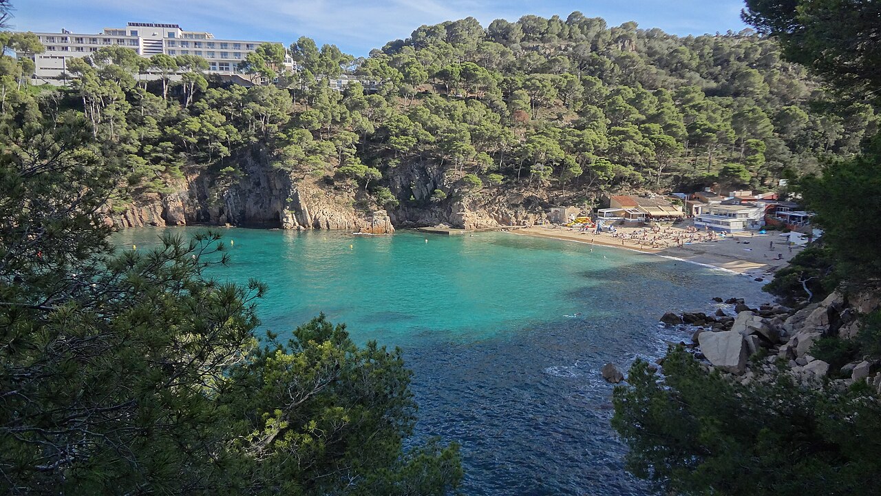
Swim out from the middle of Aiguablava with a mask on, get to about four metres of water, and look down. There are amphorae on the bottom. They are cement replicas, placed there by Catalonia’s underwater archaeology service, but they are copies of a real cargo that went down in this cove, and they sit inside the roped bathing area where anyone with a snorkel can reach them. A second group lies a little further out, at around six metres. It is the only beach in Begur where the main attraction is two thousand years old.
A Harbour in Continuous Use Since the Third Century BC
Aiguablava is not a pretty cove that happens to have some archaeology in it. It is an anchorage, and it has been one for about 2,300 years.
The reason is pure geography. Cap de Begur is a serious obstacle for anything working its way up or down this coast, and Aiguablava is the last sheltered water before you round it. Ships on the cabotage route between Empúries and Narbo — the ancient ports north and south of here — used it exactly as sailors use it now: somewhere to sit out bad weather, wait for a slant of wind, and make the crossing when the sea allowed. The headland of Cap de Begur blocks the north, Punta des Mut closes the east, and between them they cut out the tramuntana and the mestral that dominate this coastline.
The shelter has a flaw, and the flaw is the reason there is anything to excavate. A hard northwesterly could pin a vessel inside the cove with nowhere to run, and put it on the rocks. The Centre d’Arqueologia Subaquàtica de Catalunya, the underwater research unit of the Museu d’Arqueologia de Catalunya, has run campaigns here since 2006. It has documented the remains of several Roman-period ships on the bottom, spanning from around the second century BC to the second century AD, and a medieval one besides. In most cases the hulls are long gone and what survives is the cargo, along with the everyday objects thrown overboard by two millennia of crews killing time at anchor: plates, cups, cooking pots.
The best documented of them, catalogued as Aiguablava I, was a small coastal trader from the Augustan period carrying wine amphorae from the Tarraconensis. It was excavated in 2009, and the sequence that led there is a good one: in 2004 a free-diving local fisherman, Joan Gisbert, reported archaeological material he had found on the seabed to the CASC. Later that autumn the centre ran a first set of trial soundings from its working platform, turning up amphora fragments in quantity, and the work went on from there. Published accounts differ over whether those soundings were in October or November; we have not been able to settle it, and it is noted in the sources below.
The site is not finished with. In autumn 2024 the CASC probed a corner of the cove that had not been explored before, digging down to bedrock, and found a fifth wreck: a Roman ship of the imperial period, dated to the second century AD. That one matters more than the count suggests, because for the first time in this anchorage the excavation recovered preserved timber from a hull — a frame and two strakes. Everything found here before was cargo and crockery.
The anchorage, meanwhile, never stopped being an anchorage. There are a couple of hundred mooring buoys in the bay today. Everything about the place that made it useful to a Roman skipper makes it useful to a Catalan family with a boat.
One rule has changed for those boats, and 2026 is the first summer of it. Real Decreto 191/2026, published on 13 March, sets a common framework for conserving marine phanerogam meadows across the Spanish Mediterranean, with a general prohibition on anchoring over Posidonia oceanica and Cymodocea nodosa. At a bay like this one — seagrass on the bottom, a couple of hundred buoys already in the water and a protected archaeological site underneath — the practical instruction is simple. Take a buoy. There is a second reason here that does not apply elsewhere on this coast: an anchor dragging across the bottom of Aiguablava is not only crossing a protected habitat, it is crossing a documented wreck field.
Snorkelling the Amphorae
What makes this unusual is that you do not need a qualification to see any of it. The CASC sank two distinct sets of cement amphora replicas inside the swimming zone, one group at four metres and the other at six. They reproduce the cargoes of two specific ships: a second-century BC vessel carrying wine out of Italy, and one from the end of the first century BC that had loaded at Baetulo — modern Badalona — and was making for the port of Narbo. Solid cement was chosen deliberately, to make the replicas worth nobody’s trouble to steal, and they were placed as close as possible to where the originals were found. Both are reachable with a mask, a snorkel and a breath, and the water is clear enough that on a calm morning you can make them out from the surface.
Check before you count on it: the installation is a seasonal, summer-facing initiative and what is in the water varies. The dive centres on the beach or the Ajuntament de Begur will tell you what is currently down there.
If you want more than a snorkel, there are dive operators working directly off this beach, and several of them run an archaeological baptism — a first-time dive built around the site rather than around a swimming-pool exercise. The left side of the cove is the shallow, sheltered ground used for beginners and course work. The right side is the interesting one for anybody with experience: posidonia meadows give way to blocky rock and then to a canyon walled with sponges and white gorgonians. For a beach you can park at, that is a lot of seabed.
One rule, and it is not a soft one: everything archaeological down there is protected heritage. Look, photograph, leave it exactly where it is.
What the Beach Is Like
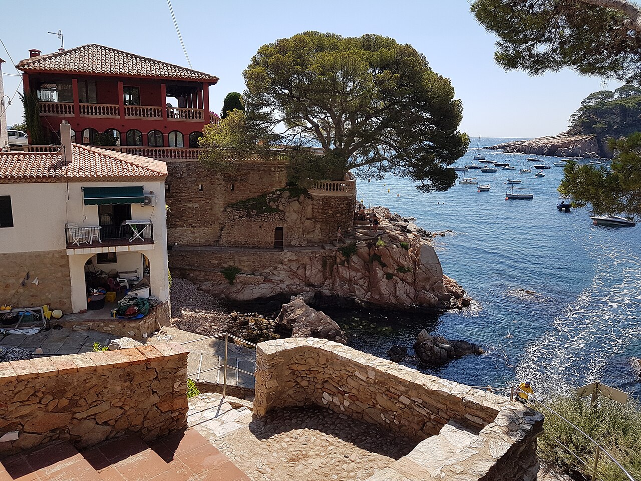
Around 75 to 100 metres of shoreline, 30 to 40 deep, and — unusually for this coast — fine golden sand rather than gravel. The slope into the water is gentle and the shallows stay shallow for a while, which is why Aiguablava is the Begur cove people bring small children to. Almost every other beach within ten kilometres involves stones and a sudden drop.
The services match: lifeguard cover in season, showers and toilets including adapted facilities, ramps for reduced mobility, a chiringuito on the sand. It is the least wild and the most usable beach in Begur, and there is no point pretending otherwise — you come here for the water and the archaeology, not for solitude.
One correction worth making, because it circulates widely: Aiguablava does not face the sunset. The cove is oriented northeast, tucked in behind Punta des Mut. What you get in the evening is the low sun striking the cliffs and the Parador on the headland opposite, which is genuinely beautiful — but the sun goes down behind you, over the land.
How to Get to Aiguablava
By Municipal Shuttle
The Bus Platges Begur is the single best decision you can make here in July or August, because it turns the hardest part of the day — the car — into somebody else’s problem. It has run every summer since 1996. For 2026 the service operates from 13 June to 13 September, daily, on three circular routes leaving from the plaça Forgas and serving Sa Riera, Sa Tuna, Aiguablava and Fornells, with runs out to Esclanyà as well.
It is also cheap enough to make the parking argument absurd: €1.50 a journey, €3 for a day ticket, €20 for a twenty-trip pass, with a reduced fare of €1 for over-65s and for children and young people aged 6 to 16, and free travel for under-5s. Tickets are bought on the bus itself or at the Begur tourist office. The start and end dates move by a few days each year — it began on 1 June in 2024 and on 14 June in 2025 — so check the current season rather than working from these.
By Car
The GIV-6542 runs the five kilometres from Begur down to the cove and it is well signposted. The car park is paid and it is small. By eleven in the morning in peak season the queue backs up the access road, and a queue on a dead-end road with nowhere to turn is a bad place to be. Before ten, or take the shuttle.
On Foot (Camí de Ronda)
Roughly twenty minutes from Cala d’Aiguafreda to the south, and about forty-five minutes north along one of the finest stretches of coastal path on the Costa Brava, past a string of small coves to Platja Fonda and the Fornells area. Further south the path links, with some inland detours, towards Cala Sa Tuna.
Map
Eating and Sleeping at Aiguablava
On the sand there is a chiringuito and a couple of cafeteria-style restaurants doing fish and seafood at beach-monopoly prices. They are fine for lunch in swimwear and nobody should expect more than that.
Above the cove, on the rock of Punta des Mut, sits the Parador de Aiguablava — a state-run hotel on one of the best sites on this coast, and open to non-residents for a meal with the whole bay in front of you. The long-established Hotel Aigua Blava occupies the other side of the same view. Between them they account for most of the accommodation at the beach itself, and both book out early for summer. Begur town, five kilometres up the hill, has the range, the prices and the shuttle back down.
When to Go
Two things here run on a calendar rather than on the weather, and both of them are the reason to come: the underwater replicas, which are a summer installation, and the municipal shuttle, roughly May to mid-September. Outside that window Aiguablava is still a lovely cove, but it is a cove — no shuttle, no archaeological park in the water, reduced services.
Inside the window, June and the first half of September are the sweet spot: the amphorae are in place, the shuttle is running, the sea is warm and the car park is survivable. July and August deliver the same water with a queue attached. If you are going then, be on the beach before ten or arrive on the bus.
Whenever you come, snorkel early. The bay fills with moored boats through the day and clarity is always best in the first hours. For how Aiguablava compares with the rest of the region’s coves, see our Costa Brava beach rankings.
Practical Tips
- Bring a mask. The amphora replicas sit at four and six metres inside the swimming area — no tank required.
- Take the shuttle in July and August. The car park is the bottleneck at this beach, not the sand.
- Swim right for the seabed, left for the shallows. Rock, gorgonians and depth on one side; sheltered training water on the other.
- Touch nothing on the bottom. The genuine material is protected archaeology and removing any of it is an offence.
- Don’t come for the sunset. The cove faces northeast; the evening light lands on the cliffs, not on the water.
Written for general information, not as travel, legal or safety advice. The archaeological material on the seabed at Aiguablava is protected cultural heritage: disturbing or removing it is a criminal offence in Spain. Replica installations, dive-centre activities and the municipal shuttle are seasonal and their operation varies year to year. The bay is a working anchorage with boat traffic — stay inside the marked swimming zone. Lifeguard cover is seasonal. Confirm current details with the Ajuntament de Begur before travelling.
Sources
Checked on 27 August 2026.
- The amphora replicas and the anchorage. Generalitat de Catalunya — official announcement of the CASC installation at Aiguablava. Source for the two distinct sets of cement replicas, their placement inside the bathing zone at four and six metres, the fact that both are reachable by snorkel as well as by diving, the campaigns run at the cove since 2006, and the documentation of Aiguablava as a natural anchorage in use since the third century BC.
- The Aiguablava I wreck. Gustau Vivar and colleagues, El derelicte Aiguablava I: un exemple de comerç de vi de la Tarraconense en època d’August, published in the journal Empúries and available through RACO. Source for the 2009 excavation, the homogeneous cargo of Pascual 1 wine amphorae from the Catalan coast, the south-to-north route towards Narbo, the absence of surviving hull timber, and Joan Gisbert’s report to the CASC in 2004.
- The northeast orientation. Joan Mayoral Peñalva of the CASC, preliminary study of the Aiguablava V wreck, published by CHAM at the Universidade NOVA de Lisboa. It states the cove’s orientation as northeast, sheltered to the north by the Cap de Begur and to the east by the Punta des Mut, where the Parador now stands. This is the source behind our note that Aiguablava is not a sunset beach.
- The fifth wreck, 2024. Reported in the Catalan press in November 2024, quoting the CASC archaeologist directing the excavation: a Roman ship of the imperial period dated to the second century AD, found by sounding an unexplored corner of the cove down to bedrock, and the first find in this anchorage to preserve hull timber — one frame and two strakes. Four wrecks were known here before it, three Roman and one medieval. We have not found a formal excavation report for this campaign, so it is cited as press coverage of the CASC’s statements rather than as a publication of the centre.
- Anchoring over the meadows. Real Decreto 191/2026, de 11 de marzo, para la conservación de praderas de fanerógamas marinas en aguas marinas del Mediterráneo español, published in the Boletín Oficial del Estado of 13 March 2026. Article 5 regulates anchoring over Posidonia oceanica and Cymodocea nodosa; article 6 covers the authorisation of low-impact mooring systems. Posidonia beds are a priority habitat of community interest under the EU Habitats Directive. The archaeological protection of the seabed is separate and additional.
- A discrepancy we have not resolved. The Empúries article places the first CASC soundings at Aiguablava in October 2004; the CHAM study places them in November of the same year, at eight to ten metres, carried out from the centre’s working platform. Both are CASC-authored. We have kept the month out of the body text rather than pick one.
- What we could not verify. The measurements of the beach, given here as ranges because published figures differ; the national register is the Guía de Playas of the Ministerio para la Transición Ecológica y el Reto Demográfico (Fuente: © Ministerio para la Transición Ecológica y el Reto Demográfico). Also unverified against an official document: the count of mooring buoys in the bay.
- The Bus Platges Begur. Ajuntament de Begur — announcement of the 2026 service. Source for the dates of 13 June to 13 September, the daily operation, the fares of €1.50 single, €1 reduced for over-65s and for 6 to 16 year-olds, €3 day ticket and €20 twenty-trip pass, free travel for under-5s, and the sale of tickets on the bus and at the tourist office. The council’s tourism service confirms the three circular routes from the plaça Forgas serving Sa Riera, Sa Tuna, Aiguablava and Fornells. An earlier version of this guide gave the season as “roughly May to mid-September”, which was too early at the start by a fortnight.
- The legal position on the seabed. Archaeological material in Spanish waters is protected cultural heritage and removing or disturbing it is an offence. The replicas are there precisely so that visitors have something they may handle with their eyes and nothing they may take.
- The accessibility provision. The adapted facilities and reduced-mobility ramps listed among the services here are installed by the Ajuntament de Begur for the bathing season and removed afterwards. We have not confirmed the 2026 dates or the extent of the installation with the town hall. Anyone planning the journey around that provision should ring ahead rather than rely on this page, because seasonal accessibility is real in August and often gone by late autumn.
Image Credits
- Header image: Platja d’Aiguablava by Isidro Jabato, licensed under CC BY-SA 4.0, via Wikimedia Commons.
- In-article image: Cala d’Aiguablava, Begur by Myriam Thyes, licensed under CC BY-SA 4.0, via Wikimedia Commons.
Leave a Reply