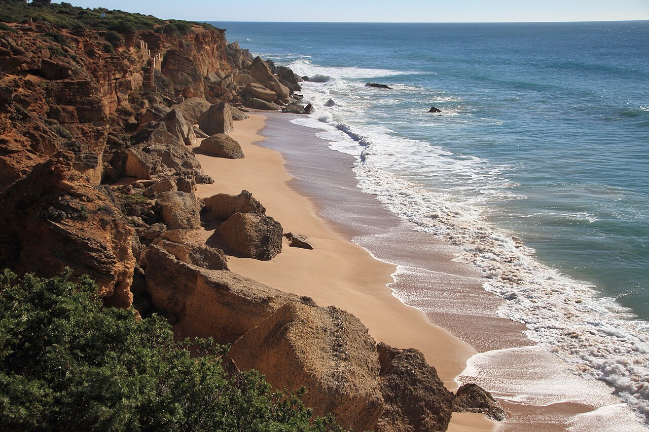
Most beach guides can tell you what a place looks like. At Roche that depends on what time you turn up, because some of these coves do not exist at high tide. The sand goes under, the sea reaches the cliff, and a beach you saw in a photograph is simply not there.
Cala de Roche is not one cove but seven — Cala del Faro, Cala Tío Juan Medina, Cala del Pato, Cala del Enebro, Cala del Frailecillo, Cala del Áspero and Cala Encendida — strung along the cliffs between Conil’s fishing port and the Roche urbanisation, each with its own staircase down. Check the tide table before you leave. It is the single most useful thing in this guide.
The Tide Decides Which Beaches Exist
At low water, several of the coves join up along the sand. You can drop down one staircase and walk two or three coves in either direction without climbing back to the cliff path, which is the best way to see this coast and the reason people come back.
At high water the picture reverses. The smaller coves lose most or all of their sand, the connections close, and getting from one to the next means going back up the stairs and along the top. That is inconvenient if you planned a walk. It is a genuine problem if you are already three coves along and the water is coming in behind you.
So: look up the tide times for Conil, aim to arrive an hour or two before low water, and keep an eye on it. This is Atlantic tidal range, not the Mediterranean — the difference between the two states is substantial, and it moves faster than people expect.
Where to Go When the Levante Blows
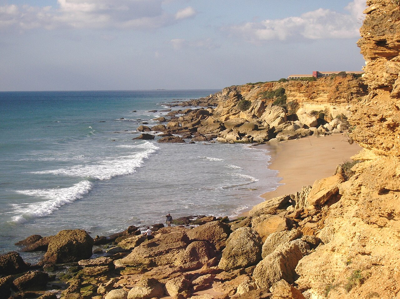
This is the other reason to know about Roche, and it is worth stating as a rule: when the easterly Levante is blowing, this is where you go on the Cádiz coast.
The beaches to the south are built for the opposite. Bolonia and the Tarifa beaches face straight into it, which is exactly why the kitesurfers are there and exactly why a strong Levante makes lying on the sand unpleasant. El Palmar is open Atlantic with nothing behind it. Roche is the opposite arrangement: cliffs of reddish clay and oyster-stone, around 35 metres high, sitting between the wind and the water.
The practical version is that on a bad-forecast day in Cádiz, the coves at Roche are usable when almost nothing else on this coast is. Cala del Pato is generally reckoned the most sheltered of the seven.
The Seven, Briefly
They run from the lighthouse end towards the urbanisation. Cala del Faro sits closest to the Faro de Roche, at the quiet end. Cala Tío Juan Medina and Cala del Pato are the ones regulars name when asked where they actually go — Pato in particular for shelter and calm. Cala del Enebro and Cala del Frailecillo are among the wider of the small ones.
Cala del Áspero and Cala Encendida, nearest the Roche urbanisation and the hotel, are the busiest by a distance, because they are the easiest to reach and Encendida has a restaurant on the clifftop above it. Encendida is named for what the cliffs do at sunset, when the clay turns properly orange. It is the best of the seven to photograph and the worst of the seven to have to yourself.
The rule of thumb is the usual one: walk away from the car park and the numbers fall off fast.
Two footnotes to the list. Cala del Pato is named for a rock whose outline suggests a duck’s head, and the rocky bottom close inshore makes it the best of the group for snorkelling on a calm day — so it is the pick for shelter and for the mask both. And the count of seven is a convention rather than a fact: some listings add Cala Paneque, also called Cala Bonita, tucked between Tío Juan Medina and Cala del Pato and effectively continuous with the latter. It is the quietest of all of them, which is why the people who know it tend not to count it.
On nudism: it is common in the quieter coves away from the main accesses, none of the group is officially designated naturist, and nobody makes an issue of it either way.
The Cliffs Are Actively Falling Down
The disclaimer at the foot of this guide says the cliffs are prone to erosion. That undersells it, so here is the specific version.
These are clay and soft sandstone, not granite, and they are coming apart on a timescale you can measure in seasons rather than centuries. The staircases you use to get down were built in 1993 by the Cádiz coastal authority, in rustic materials fitted to the slope, dropping more than ten metres in places. Storms, rainwater running off the top and ordinary erosion of the slopes have been degrading them ever since. Before the most recent repair programme, two of them — the accesses to Cala del Faro and Cala del Pato — were completely impassable, with a section of stair broken clean away.
It happens to the cliff face too, not just the stairs. The stairway cut into the rock at Cala Paneque, between Tío Juan Medina and Cala del Pato, was destroyed by a rockfall in 2012 and not repaired until 2015. And on the morning of Good Friday, 3 April 2026, part of the cliff came down onto the sand at Cala Puntalejos, a little further along the same coast. It was early, and the beach was empty. Within a few hours the same stretch was full of people, some of whom set up under the fresh debris.
Which gives you the two rules that matter here, and they cost nothing to follow:
- Do not sit at the foot of the cliff. The shade down there is tempting in August and it is the worst place on the beach to be. Put the towel out on open sand.
- Use the built staircases only. Scrambling down an unmade section of clay slope is how people get hurt here, and it accelerates the erosion that closes the proper accesses.
Add one practical consequence: any individual access can be closed for repair at any time, and the published list of open staircases is not always current. If a stairway is taped off, the next cove along is usually a five-minute walk on the clifftop path.
The Cliff Path and the Lighthouse
A marked path runs along the clifftop from the Faro de Roche to the urbanisation, linking all seven coves, with the sea beside you the whole way. Out and back is around five kilometres and it is flat, which makes it one of the easier coastal walks in the province.
Part of the way along there is a birdwatching point, and it is there for a reason: Cabo Roche sits on one of the main migratory corridors for spoonbills moving between the Iberian Peninsula and Africa. Spring and autumn are when that is worth stopping for.
The Faro de Roche itself dates from 1983 and stands on a 16th-century watchtower — the same chain of towers built against Barbary raiding that runs the length of this coast. From the viewpoint you can see as far as the Faro de Trafalgar in one direction and the Cala del Aceite cliffs in the other.
Getting There
By car. Leave the N-340 at the Roche turning around kilometre 18, about 3 kilometres from Conil, and continue into the urbanisation; alternatively the CA-4202 runs along the coast from Conil’s port. There are four parking areas along the road, each with a short path or boardwalk to one of the main coves.
On foot. From Conil’s Playa de la Fontanilla it is about an hour along the coast. Starting at one end and working through to the other is how to see all seven in a single outing.
Every cove is reached by wooden stairs with handrails — renovated, in reasonable condition, and unavoidable. There is no step-free access to any of the seven, which rules the place out for wheelchairs and makes it awkward with a pushchair.
Map
The map points to the Faro de Roche, which marks one end of the clifftop trail. The coves span a stretch of coast rather than a single address.
Eating, Staying, and When to Come
Cala Encendida has a restaurant on the clifftop directly above it — the only cove of the seven with food at hand. Everywhere else, bring it with you. The Roche urbanisation has a few more options, including the four-star Ilunion Calas de Conil, and Conil’s port area has the proper range: this is Cádiz tuna country, and Conil is one of the almadraba towns.
For accommodation, Roche has the hotel plus villas and apartments near the coves; Conil, a short drive or an hour’s walk away, has far more of everything.
On timing, this is a place where the forecast matters more than the month. Water runs from around 16 °C in winter to 22–23 °C in August, and the coves are pleasant across most of that range. What changes the day is wind and tide, not season. Avoid August at Encendida and Áspero if you can, go early if you can’t, and pick Roche deliberately on the days the rest of the coast is being sandblasted. Our ranking of the best beaches in Andalucía covers the alternatives.
Practical Tips
- Check the tide table for Conil first. Everything else here follows from it.
- Don’t get caught along the sand on a rising tide. Know where the nearest staircase is.
- Come here specifically when the Levante is blowing. That is the point of the place.
- Cala del Pato for calm; Encendida for the sunset and the crowd that comes with it.
- Bring food and water beyond Encendida. Nothing else has services.
- Stairs at every access point, with no step-free alternative.
General travel information, not professional or safety advice. Tides here are Atlantic and the range is significant: check current tide tables for Conil, and do not rely on walking between coves without them. Lifeguard cover, cleaning and parking arrangements vary by cove and by season — confirm with the Ayuntamiento de Conil de la Frontera. The cliffs are clay and prone to erosion; keep away from the base and the edge.
Sources
- The staircases. Ministerio para la Transición Ecológica y el Reto Demográfico — record of the repair works on the accesses to the Conil coves. Source for their construction in 1993 by the Demarcación de Costas de Cádiz within the maritime-terrestrial public domain, for the drops of over ten metres they negotiate, for the degradation caused by storms, runoff and slope erosion, and for the two accesses — Cala del Faro and Cala del Pato — that were left impassable by a complete break in a section of stair.
- The rockfalls. The collapse at Cala Puntalejos on the morning of 3 April 2026 was reported by the Cádiz press, which also noted that the cliff stabilisation project for the Fuente del Gallo stretch was finally carried out in 2025 after years of delay. The destruction of the rock-cut stairway at Cala Paneque in 2012 and its repair in 2015 are documented in local records of the coves.
- Tides. This is the Atlantic coast and the range is significant. Use current tide tables for Conil rather than any figure published in a guide, this one included, and remember that the connections between coves close well before high water rather than at it.
- Lifeguard cover, cleaning, parking and the state of individual accesses are set by the Ayuntamiento de Conil de la Frontera and by the coastal authority, and change within a season. Cleaning at these coves is done by hand, which is the practical reason for carrying your rubbish back up the stairs.
Image Credits
- Header image: Calas de Roche, Costa de la Luz, Conil by PEPE GADEIRAS, licensed under CC BY-SA 4.0, via Wikimedia Commons.
- In-article image: Bucht Roche by Camper2, licensed under CC BY-SA 3.0, via Wikimedia Commons.
Leave a Reply