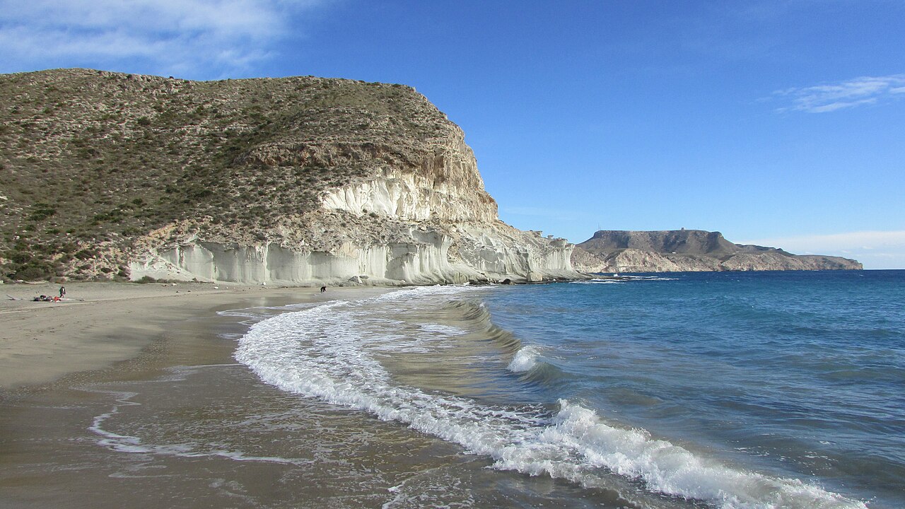
Cala de Enmedio is 130 metres of dark sand at the mouth of a dry riverbed, and there is no road to it. There never has been. You walk in from Agua Amarga, walk in from the Cala del Plomo track, or arrive by kayak — and that constraint, more than anything else, is why a cove Guía Repsol placed in its 2012 list of the ten most beautiful places in Spain still feels like something you found rather than something you queued for.
The other reason is the rock. At both ends of the cove, pale formations rise out of the sand and run into the water in smooth, curved ledges that look poured rather than eroded. They are dunes that turned to stone, and they are what people photograph here.
Dunes That Turned to Stone
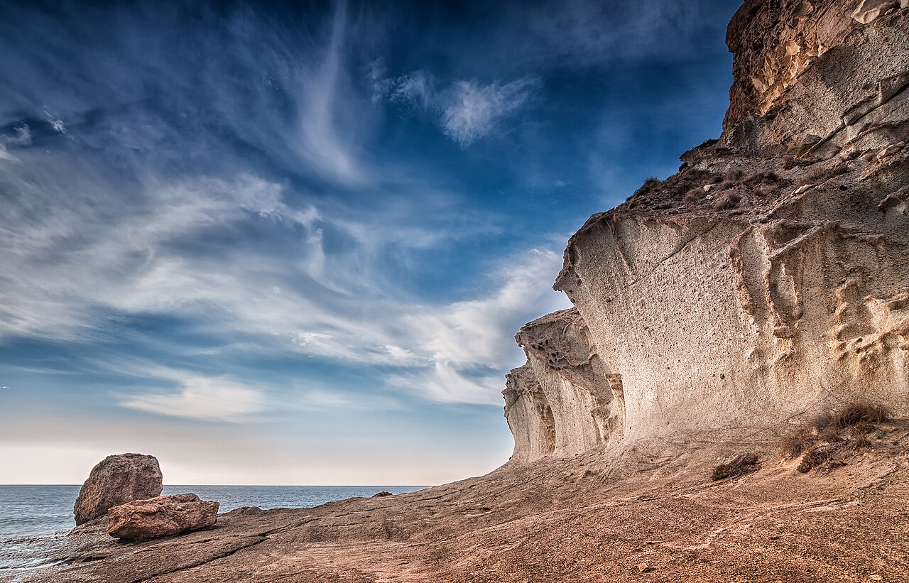
The white rock flanking the cove is fossilised dune — sand blown into place long ago, then cemented by carbonate into a soft, pale stone. Once it hardened, the wind and the sea started taking it apart again, and because the rock is soft and layered they have been able to carve it into ledges, overhangs and shallow pools rather than simply breaking it up.
The two ends of the cove are not the same, which is worth knowing before you settle on a towel. One side has the smoother, more sculptural formations that run out into the water; the other has the pools and platforms people sit on. Walk both before choosing.
One request the park makes and most visitors ignore: the rock is soft. Scratching names into it takes seconds and lasts decades, and there is already more of that than there should be.
A Cove Built by a Dry River
Cala de Enmedio sits at the mouth of the Rambla de la Cala, wedged between the Cerro del Cuartel and the Cerro de la Higuera. A rambla is a watercourse that is dry almost all the time — this is one of the driest corners of Europe — and then, a few times a decade, carries an enormous amount of water very quickly after a storm inland.
That is where the beach comes from. The rambla brings sediment down off the hills and dumps it at the sea, and the sea sorts it. It also explains a detail people notice without knowing why: the sand here is fine and almost completely free of stones, unusual on a coast where most coves are pebble or shingle. The stones stay upstream; only the fine material makes it to the mouth.
It is also worth taking seriously. If there is a storm warning inland, a rambla bed is not where you want to be walking, however blue the sky is above the coast.
The Two Walks In
From Agua Amarga. The standard route. It starts on Calle Depósito, climbs out of the village on a paved track that turns to dirt past the last houses, rounds the Cerro del Cuartel and drops into the ravine behind the cove. One thing this cove does have going for it in high summer: Agua Amarga sits outside the regulated stretch, so none of the vehicle restrictions described in our guide to Cabo de Gata beach access in 2026 apply here. The walk is the barrier instead. Between 1.7 and 2 kilometres, 30 to 40 minutes, well marked. There is no shade on any of it.
From Cala del Plomo. Quieter and shorter on foot, longer in the car. Take the Hernán Pérez turning off the Agua Amarga road and follow around 7 kilometres of dirt track to the Plomo parking area, then take the path opposite the Cortijo de la Huerta de Enmedio. Mountain bikes are allowed on the approach track; motor vehicles are not, and that rule is the reason the cove is still what it is.
By sea. Operators based in Agua Amarga run guided kayak trips that take in Enmedio and carry on to Cala del Plomo, generally quoted at two to three hours. We have not verified the season, the price or the party sizes with any of them, so treat that as a description of what is on offer rather than a timetable. It is the least strenuous option and gives you the cliffs from the angle the walkers do not get.
Map
The map points to Agua Amarga, where the main trail starts. Cala de Enmedio has no road access and no address for Google to pin.
Once You’re Down There
The water is clear, deep blue, and enters over sand rather than rock, which makes it a comfortable swim by the standards of this coast. Snorkelling is good along the base of the fossil dunes at either end — there is no urban runoff anywhere near here, and the visibility shows it.
Nudism is common and entirely uncontroversial, alongside people in swimsuits, though the cove has no official naturist designation. Nobody pays attention either way.
And there is nothing else. No bar, no toilet, no shower, no lifeguard, no bin, no shade except what the rock throws late in the day. Everything you want has to come down the path on your back, and everything you brought has to go back up it.
Agua Amarga, and When to Come
Agua Amarga is a former fishing village of white houses and bougainvillea with a wide, shallow beach of its own and a seafront of restaurants — the obvious base, and the place to eat after the walk back. Las Negras, further south, is quieter and works the same way. Both are within reach of the rest of this coastline, including Playa de los Muertos a little to the north.
June and September are the best months here, and the reason is the trail rather than the water: warm enough to swim, cool enough to walk 2 kilometres without shade. August is manageable if you are on the path before nine in the morning and prepared for the walk back in full heat — a lot of people underestimate that second half. Spring and autumn are for the geology and the quiet more than for swimming, and the cove is close to empty. Our ranking of the best beaches in Andalucía has alternatives if the walk doesn’t suit.
If You Are Coming by Kayak
Two park-wide rules changed recently and both matter here, because arriving by sea is one of the three ways in.
Groups of more than five kayaks are restricted. A resolution of 18 February 2025 regulates recreational activity by groups of kayaks, canoes and similar unpowered craft on specified beaches inside the park. If you are booking a guided trip out of Agua Amarga, this is why party sizes are what they are, and why an operator who tells you they can take a group of fifteen along the coast in one flotilla is telling you something that is no longer true.
Motorised watercraft are now banned outright. Under a resolution of 1 December 2025, jet skis and similar craft are prohibited across the whole protected coastal strip — the full marine band out to roughly a nautical mile, around twelve thousand hectares of water. Summer 2026 is the first season it applies. For a cove where the appeal is the quiet and the visibility over the seagrass, that is the single most consequential change of the year, and it is a habitat measure rather than a crowding one: no quota, no rotation, nothing to work around.
The Rambla Is Not a Formality
Worth expanding on the warning above, because it is the one thing here that can genuinely hurt you and it is counterintuitive.
A rambla drains a catchment. The Rambla de la Cala collects water from the hills inland and delivers it to the sea through the channel you walk down. In a landscape this dry the ground does not absorb; a short, violent autumn storm inland — the kind Almería gets from cut-off lows in September and October — can put a large volume of water into the bed very quickly, and it arrives from behind you.
Which means the sky above the cove tells you nothing. The rain that fills a rambla often falls twenty or thirty kilometres away, over ground you cannot see from the beach, and the coast can stay blue and calm while the bed behind it fills. If there is a storm warning anywhere inland, the answer is not to hurry — it is not to be in the channel at all. The same applies to the walk in from Cala del Plomo, which crosses similar ground.
This is not a theoretical caution in this province. It is the reason the sand at the cove is fine and stoneless in the first place: the rambla has been doing this, episodically and hard, for a very long time.
Practical Tips
- Two litres of water per person, minimum. There is nowhere to refill and no shade on the path.
- Trail shoes or sturdy sandals. Parts of the route are loose and stony.
- Before 9am in August, and plan for the return leg being the hard one.
- Bring your own shade. The rock gives some late in the afternoon; that is all.
- Walk both ends of the cove before you settle. They are genuinely different.
- Don’t carve the soft rock, and take your rubbish back out with you.
Frequently Asked Questions
Can you drive to Cala de Enmedio?
No. There is no road. It is on foot from Agua Amarga or Cala del Plomo, by mountain bike on part of the Plomo track, or by kayak.
Do the Cabo de Gata access restrictions apply here?
Not the ones on land. Agua Amarga lies outside the regulated stretch, so the barrier, the 399-vehicle quota and the fee described in our Cabo de Gata access guide do not apply to this approach — the walk is the barrier instead. The marine rules do apply: groups of more than five kayaks are restricted under a resolution of 18 February 2025, and motorised craft are prohibited across the whole protected strip under a resolution of 1 December 2025, in force for the first time this summer.
General travel information, not professional or safety advice. Trail conditions inside Cabo de Gata-Níjar change, and the routes are exposed and unshaded — check the forecast and carry enough water. There is no lifeguard, no drinking water and no phone signal to rely on at the cove. Avoid the rambla bed entirely if storms are forecast inland, and treat the fossil dune formations as the protected feature they are.
Sources
Checked on 30 August 2026.
- The park rules. The resolution of 18 February 2025 regulating motor-vehicle access and groups of kayaks on specified beaches, and the resolution of 1 December 2025 prohibiting motorised watercraft throughout the protected coastal strip, are both listed on the park’s page on the Junta’s Ventana del Visitante. Agua Amarga sits outside the regulated vehicle stretch, so the barrier described in our Cabo de Gata access guide does not apply to this approach — but the marine rules do.
- The geology. The fossil dune formations, and the wider volcanic sequence they sit in, are described by the Cabo de Gata-Níjar UNESCO Global Geopark. Our guide to Playa de Mónsul sets out the geological history of the park in more detail, along with the full sequence of protective designations.
- On the Guía Repsol listing. The attribution is specific and consistently reported: the 2012 edition placed Cala de Enmedio among the ten most beautiful places in Spain.
- A claim we have removed. Until August 2026 this guide repeated, as most pages about this cove do, that the New York Times has written about Cala de Enmedio. We have not been able to trace that to an actual article. Every source repeating it attributes it vaguely — “a piece in its magazine”, “some time ago” — and none links anything. The one version carrying a strong headline comes from an outlet we would not rely on for anything else. Until somebody produces the article, we are treating it as an unverified attribution and it is no longer in the text. If you can point us to it, please tell us and it goes back in with a link.
- Two things we have softened. This guide called this the driest corner of Europe. The claim circulates widely and the south-east of Almería is genuinely at the arid end of the continent, but we have not found it stated in a source we would cite, so the guide now says one of the driest and leaves it there. Our guide to Cala de San Pedro carries the same wording for the same reason. We have also stopped presenting the kayak trips out of Agua Amarga as though we had checked them; we have not spoken to an operator, and the paragraph now says so.
Image Credits
- Header image: Cala enmedio 04 by MdeVicente, licensed under CC BY-SA 4.0, via Wikimedia Commons.
- In-article image: Cala de Enmedio by Dgalan, licensed under CC BY-SA 4.0, via Wikimedia Commons.
Leave a Reply