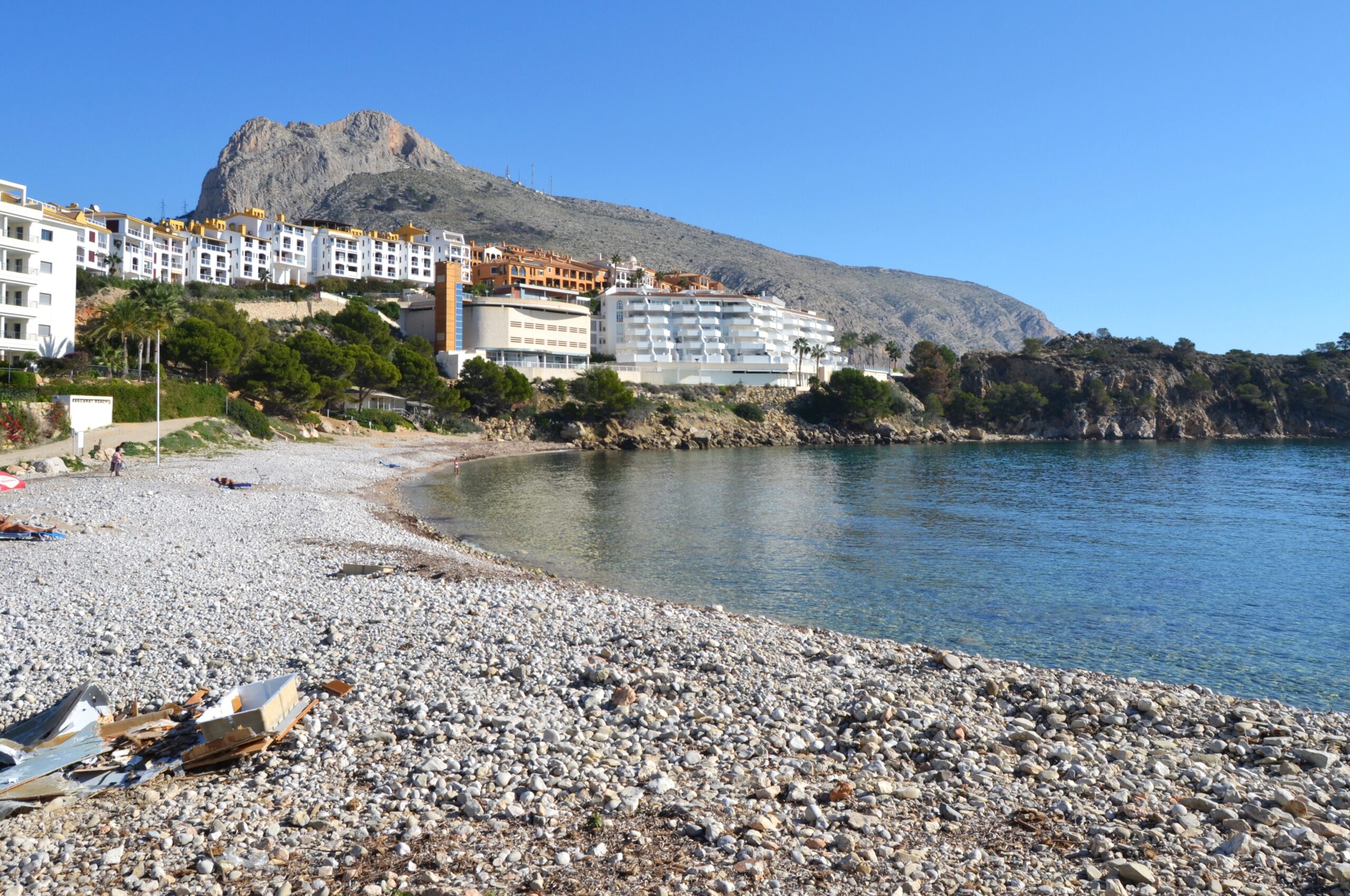
For centuries, the gorge directly behind this beach was the reason people avoided this stretch of coast. The Mascarat is where the Sierra de Bernia falls into the sea and the coastal road has to squeeze through a cleft in the rock — a natural chokepoint, historically the most feared pass between Altea and Calpe, watched over by a castle and, by most accounts, worked by bandits. Today three bridges cross it at different heights and you drive through in twenty seconds without noticing. The beach sits at the bottom of it.
It is pebbles, not sand, it has no Blue Flag, and it is one of the better places to put a mask on in this part of Alicante. A few minutes north, Playa de la Fossa in Calpe is the exact opposite proposition.
Where Is Playa Mascarat?
At the northern edge of Altea, province of Alicante, where the town’s coastline meets the Sierra de Bernia and gives way to Calpe. The beach comes in two adjoining sections — Mascarat Norte and Mascarat Sur, also called La Barreta — divided by the Punta del Mascarat headland, with the Puerto Campomanes marina alongside.
The headland and the marina’s north breakwater between them close off the inlet, which is why the water here stays calm when the coast either side of it does not. How much that shelter is worth on any given day depends on which wind is blowing, and the difference between Levante, Poniente and Tramuntana is what decides whether a sheltered cove is the right call or an unnecessary detour.
The Pass Behind the Beach
The Barranco del Mascarat is the geological feature that defines this whole corner of the coast. The ravine cuts inland through vertical limestone, and the route through it was for a long time the only practical way along this shoreline — narrow, overlooked from above, and with a reputation bad enough that travellers took detours to avoid it.
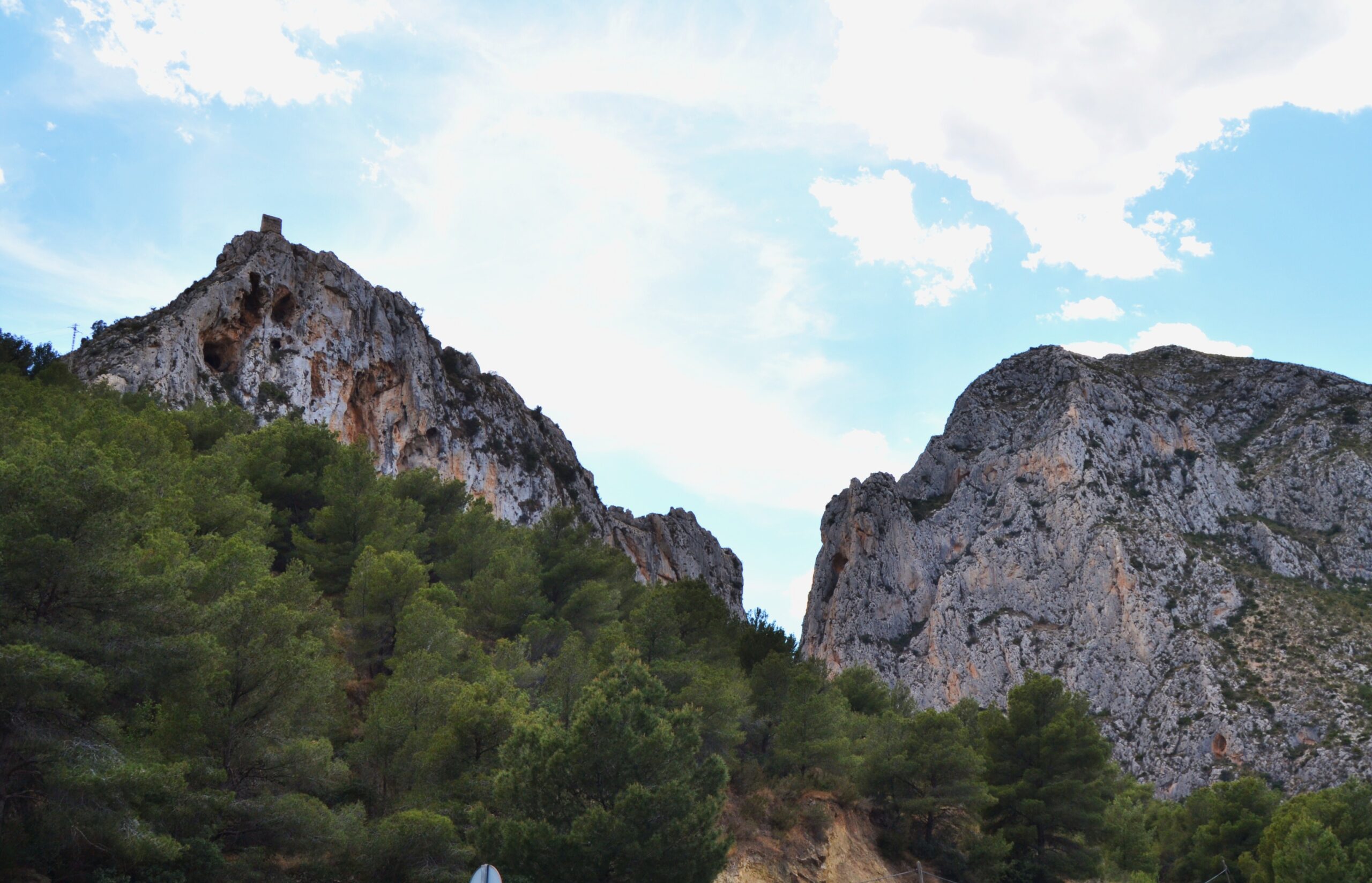
On the hill above sits the ruined Castell del Mascarat, also called the Torre del Castellet, declared Bien de Interés Cultural in 1996. Little of it survives beyond a wall, but its position explains everything about why it is there. It belongs to the same chain of coastal watch positions as the towers above Cala Ambolo, Granadella, and Cala del Portitxol further north.
The modern version of the same problem is visible from the beach: three separate bridges cross the ravine at different heights, carrying the old coast road, the narrow-gauge railway, and the AP-7 motorway. Walking up the dry riverbed and looking up at them stacked overhead is the single most striking thing to do here, and it costs nothing.
The full canyon route runs roughly 5 kilometres of dry riverbed walking to the gorge proper. The trailhead is not walkable from the beach — you need a car or a taxi — which is the one piece of planning this beach requires.
What the Beach Is Actually Like
Around 280 metres of shoreline across both sections, averaging about 21 metres wide, made up of bolos — smooth rounded stones — with no sand anywhere. Water shoes are not optional. Behind it, the near-vertical limestone of the Sierra de Bernia, which is most of the reason people photograph the place.
The two halves are governed differently and it catches people out: nudism is permitted at Mascarat Norte and not at Mascarat Sur / La Barreta. Worth knowing which side you are walking onto.
There is no Blue Flag here, generally attributed to the semi-urban setting rather than to any water quality problem.
An earlier version of this guide stated that the beach sits inside the marine area of the Serra Gelada protected zone. We have removed that, because we cannot stand it up. The Parc Natural de la Serra Gelada i el seu entorn litoral was declared in 2005 and does take in part of Altea’s territory, but it is built around the Serra Gelada ridge and the waters off it, between Benidorm and the Alfàs–Altea bay — which is the coastline south of Altea town. Mascarat is at the northern edge of the municipality, on the Calpe boundary, several kilometres the other way. Until we have seen the boundary on an official map we are not going to tell you which designation, if any, covers the water you are swimming in.
In the Water
Rocky seabed and Posidonia oceanica meadows, which is the combination that produces the clarity. On settled days this is among the better casual snorkelling spots around Altea — a rocky outcrop at the edge of the cove lets you watch the seagrass beds moving without getting in at all, and a viewpoint slightly further up gives the postcard shot over the whole inlet.
The honest caveat, which visitor accounts are consistent about: after a storm or a rough spell, weed and turbidity can flatten visibility completely. This is a beach where checking the previous few days of weather matters more than checking the forecast for the day itself.
The marina next door makes this a practical launching point for boat and kayak trips, including the run out to the sea cave known as the Cova dels Colòms — a half-day outing and the standard excursion from this stretch of coast.
Getting There
By car, leave the AP-7 at exit 64 for Altea and follow signs for Calle Mascarat or Playa del Mascarat; the N-332 also runs close by. Parking near the cove is tight in season, and some of the surrounding streets are residents-only, so read the signage rather than assuming.
The Altea–Calpe intercity bus stops around 400 to 500 metres away, which makes this one of the more bus-friendly coves on this coast. The nearest train station is Altea, about 5 kilometres off, from which you need a taxi. Water taxis and boat excursions from Altea and Calpe also run here for anyone who would rather arrive by sea.
Eating and Staying
Two chiringuitos sit at either end of the cove — Chiringuito Mascarat on the headland side, well regarded locally for paella and fresh cuttlefish, and a second beside the breakwater near the marina that works better as a drinks stop. Puerto Campomanes, a short walk away, adds restaurants, cafés and a bakery, with a supermarket about a kilometre off.
Apartment complexes sit directly above the cove with sea views and direct access, which is the convenient option. Altea’s town centre, a short drive south, has the hotels, the restaurants, and the whitewashed old town that the area is actually known for.
When to Go
Water runs from around 14–17°C in winter to 26–27°C in August. But at this particular cove, the state of the sea over the preceding days matters far more than the month.
| Period | Snorkelling | The canyon and the castle |
|---|---|---|
| April – May | Cold, but often the clearest water of the year | Ideal — mild and dry |
| June | Warming up, generally settled | Still comfortable early in the day |
| July – August | Warmest water; cove busier but never packed | Too hot for the riverbed walk |
| September – October | The best combination of warmth and clarity | Good again, better light |
| November – March | Cold and frequently stirred up by storms | The season for it — empty and cool |
Practical Tips
- Water shoes. Rounded stones the whole way, and they shift underfoot at the waterline.
- Look at the last three days of weather, not today’s. Clarity here is a function of what the sea has been doing recently.
- Norte permits nudism, Sur does not. Pick your side before you unpack.
- Read the parking signs. Parts of the surrounding development are residents-only.
- Walk into the ravine even if you skip the full hike. Ten minutes up the dry bed gets you under the three bridges, which is the thing worth seeing here.
Seasonal lifeguard and rescue equipment, showers, foot-washing points and restrooms, sunbed rental in summer, and an anchorage for small boats. Pets are permitted, though it is worth confirming peak-season rules with the Ayuntamiento de Altea.
Chiringuito openings, lifeguard cover, and parking restrictions around the Mascarat development are seasonal and set locally; the Ayuntamiento de Altea is the authority to check. Nothing here is safety advice — the Barranco del Mascarat is a dry riverbed and should not be entered when rain is forecast, and the rocks at the cove’s edges are slippery when wet.
Sources
Checked on 27 August 2026.
- A protection claim we withdrew. The Parc Natural de la Serra Gelada was declared by Decree 129/2005 of 29 July of the Consell and covers around 5,564 hectares across Benidorm, l’Alfàs del Pi and Altea, of which the great majority — roughly 4,900 hectares — is marine. The park’s own material places that marine area in the bay of Benidorm, the l’Alfàs del Pi–Altea bay and the foot of the Serra Gelada cliffs. None of that is the northern edge of Altea. We previously asserted that this beach lies inside it; we have taken the claim out rather than adjust it, and we will put a designation back only when we can point at a boundary. One finding should be recorded here because it cuts the other way: the Ajuntament d’Altea’s own environmental pages date the marine protection of the bay to 2005, and some local accounts place the northern limit of the protected marine strip at the Puntal del Mascarat itself — which would put this cove precisely on the edge of the park rather than outside it. We have not found that limit in the park’s own documentation, the two descriptions do not agree, and we are not going to publish a designation on the strength of the weaker one. Note also that Decreto 58/2005 of 11 March, which those accounts cite, approves the park’s Plan de Ordenación de los Recursos Naturales; the park itself was declared by the later Decreto 129/2005. They are different instruments and are frequently confused.
- Posidonia, whatever the designation. The seagrass here is real and it is what produces the clarity. Posidonia oceanica beds are a priority habitat of community interest under the EU Habitats Directive regardless of any local park boundary, and since 13 March 2026 Real Decreto 191/2026 has set a general prohibition on anchoring over them across the Spanish Mediterranean. A regional layer applies as well: Decreto 64/2022 of 20 May, of the Consell, governs the conservation of seagrass meadows throughout the Comunitat Valenciana. Both apply here whatever the park boundary turns out to be, and both matter at a beach with a marina next door.
- The castle. Coastal watchtowers and fortifications of this kind hold Bien de Interés Cultural status through the decree of 22 April 1949 and the second additional provision of the Ley 16/1985 del Patrimonio Histórico Español. We give the specific 1996 declaration date for the Castell del Mascarat as reported rather than as verified against the register.
- The nudism rule. The difference between the two halves — permitted at Mascarat Norte, not at Mascarat Sur or La Barreta — is a municipal matter under article 115 of the Ley 22/1988 de Costas, which gives councils competence over beach use on state-owned land. We have not been able to link the current Altea ordinance, so read the signage at the cove: that is the version an officer would be working from, and it is the version that can change between seasons.
- What we could not verify. The 280 metres of shoreline and average width of 21 metres; the five-kilometre length of the canyon route; the AP-7 exit number; the bus stop distance of 400 to 500 metres; and the historical reputation of the pass for banditry, which is widely repeated in local accounts but which we have not traced to a documentary source. The national beach register is the Guía de Playas of the Ministerio para la Transición Ecológica y el Reto Demográfico (Fuente: © Ministerio para la Transición Ecológica y el Reto Demográfico).
- The ravine. The Barranco del Mascarat is a dry watercourse. Dry watercourses in this region fill fast and violently in autumn storms, and the advice not to enter one when rain is forecast anywhere upstream is not a formality. Nobody supervises this.
- The Blue Flag. Where this guide refers to Blue Flag status, the award is administered in Spain by ADEAC, which publishes the list of awarded beaches (PDF). It is a voluntary certification a town hall applies for rather than a public designation, it measures municipal management rather than natural water quality, and the 2026 round runs for two years rather than one. Our guide to what the award measures sets out why several of the best coves in these guides do not have one.
Image Credits
- Header image: Altea, platja del Mascarat by Joanbanjo, licensed under CC BY-SA 4.0, via Wikimedia Commons.
- In-article image: El castell del Mascarat vist des de la carretera by Joanbanjo, licensed under CC BY-SA 3.0, via Wikimedia Commons.
Leave a Reply