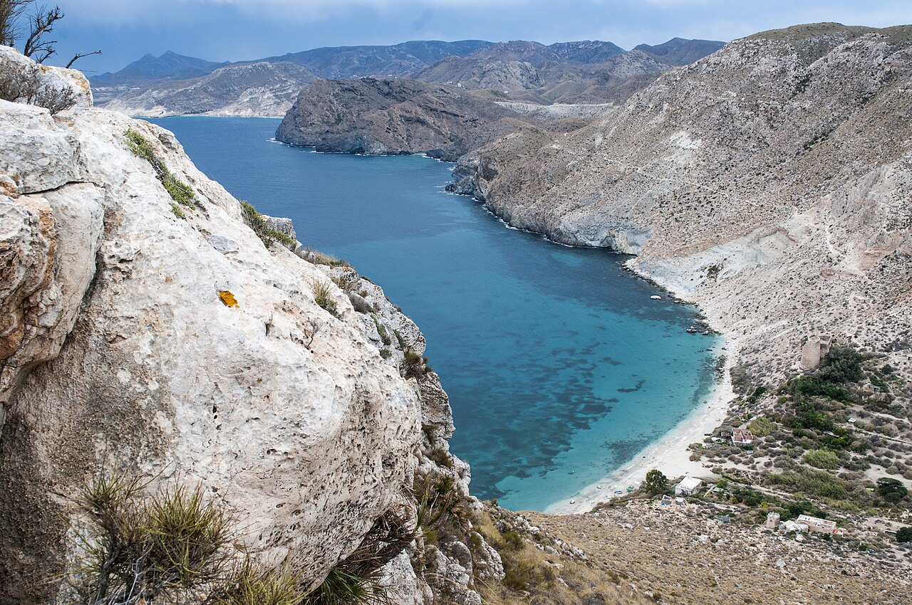
There is fresh water at Cala de San Pedro. In one of the driest corners of Europe, in a park where every other cove is bone dry and you carry in everything you drink, this one has a spring that has never stopped running. That single fact explains the whole place: the fortification above the beach, the green valley behind it, and the community that has been living there off the grid for more than forty years.
It is also one of the hardest beaches in Cabo de Gata to reach — no road comes near it — and easily the strangest.
A Fort Built Around a Spring
The ruin on the promontory is the Castillo de San Pedro, and it went up in stages on the site of an earlier Muslim military building. An artillery tower dates from 1583; the fort as it now stands was largely rebuilt in 1772 to a design by the military engineer José Crame, after earthquakes in the 17th century did their share of damage.
Why this cove in particular? Two reasons, and they are the same two that bring people today. It is a natural sheltered anchorage, usable when the coast either side of it is not. And it has drinking water. A garrison needs both.
The castle is a listed ruin and it is closed to visitors because of its structural condition. You look at it from the cove; you do not go inside it. That is not a formality — it is a 250-year-old wall with nobody maintaining it, an hour’s walk from the nearest road.
The Valley and the People in It
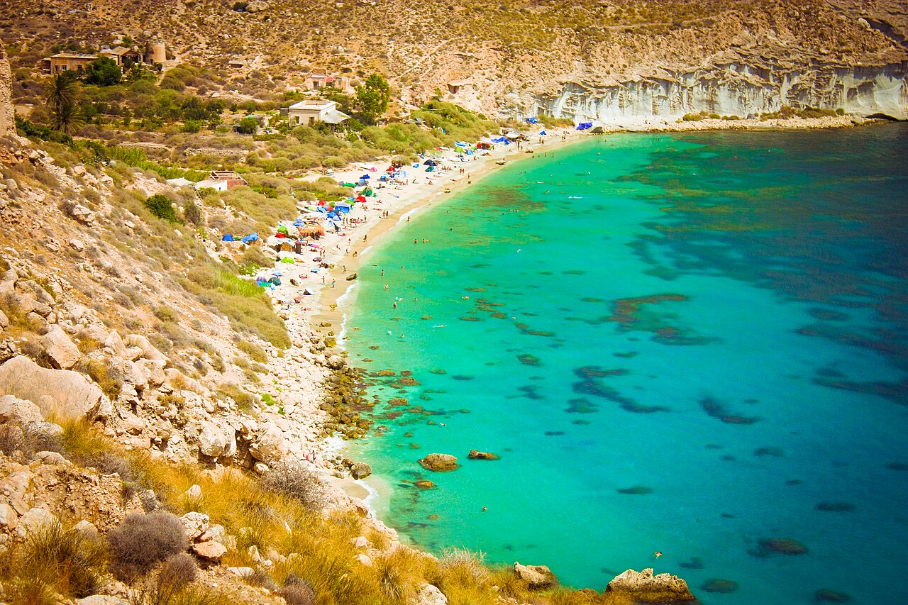
Come over the last rise and the Valle de San Pedro is green, which after an hour of grey-brown scrub is genuinely disorienting. Vegetable plots, cane, fruit trees — all of it downstream of the spring.
People have been living in that valley for more than four decades, in houses built from stone, wood, cane and reclaimed material, growing food with spring water and running without mains power, water or refuse collection — off-grid by geography rather than ideology, since there is no grid to connect to. The population shifts with the season and grows considerably in summer. A handful of informal bars run by residents sell drinks and snacks, inconsistently.
Worth being straightforward rather than romantic about it. This is somebody’s home, not scenery, and visitors are generally welcome to walk through if they behave like guests. It also sits inside a protected natural park where camping, permanent building and commercial activity are all restricted, rubbish accumulates because nothing collects it, and the legal position of the settlement has never been settled. Carry your own waste back out. One thing that does not complicate a visit here is the summer barrier: Las Negras sits well outside the regulated Genoveses–Mónsul stretch covered in our guide to Cabo de Gata beach access in 2026, so nothing on this side of the park closes on a clock.
The Four Ways In
On foot from Las Negras. The coastal trail leaves from the village beach and runs 4 to 5 kilometres to the cove — roughly forty minutes at a brisk pace, closer to an hour at a normal one, and longer coming back. Mostly straightforward walking, with one rockier, narrower and more exposed stretch near the cove that is not suitable for young children or anyone unsure on their feet. No shade anywhere on it.
By car to a nearer trailhead. There is a parking area around 2 kilometres from the beach, reached by local roads into the park, which cuts the walk considerably. The last stretch is still on foot; nothing drives to the cove.
By boat from Las Negras. Small boats and water taxis run from the village beach, 10 to 15 minutes each way, with tickets sold from a wooden booth on the sand in summer — historically in the region of €12–15 return. This is how most visitors arrive, and the obvious choice in July and August or if the walk back in the heat does not appeal. It is seasonal, so check on the day.
By kayak. Guided trips from Las Negras take about an hour each way depending on conditions. Enjoyable, and entirely weather-dependent.
The same coastal path continues south past Cala del Plomo toward Cala de Enmedio, if you are covering several coves in one trip.
Map
The map points to Las Negras, where the trail and the boats start. Cala de San Pedro has no road access and no address to pin.
Two Rules That Changed for 2026
Two of the four routes in are by water, so both of these matter here even though neither has anything to do with the barrier system further south.
Groups of more than five kayaks are restricted. A resolution of 18 February 2025 regulates recreational activity by groups of kayaks, canoes and similar unpowered craft on beaches inside the park. If you are booking a guided paddle out of Las Negras, that is why party sizes are what they are.
Motorised watercraft are banned outright. Under a resolution of 1 December 2025, jet skis and similar craft are prohibited across the entire protected coastal strip of the park — the full marine band, roughly a nautical mile out. Summer 2026 is the first season it applies. The water taxis from Las Negras are a passenger transport service and are a different matter; what has gone is the option of hiring a jet ski and riding it round to the cove.
For a bay whose whole appeal is the quiet and the clarity over the seagrass, the second of those is the most consequential change here in years.
Why the Castle Is Closed, and What That Means
The closure is not a local decision taken lightly. Castles and fortifications in Spain have been under blanket state protection since a decree of 1949, and the heritage law of 1985 confirmed them all as Bienes de Interés Cultural — the highest category in Spanish heritage law. That status brings a duty of conservation and it also brings penalties for damage.
Which produces the situation you find at San Pedro: a protected monument that nobody can easily maintain, because getting materials and machinery to it means the same hour-long coastal path everyone else walks. The fabric deteriorates, the closure stays, and the two facts reinforce each other.
So treat the ruin as what it is: a listed 250-year-old structure with no supervision, an hour from the nearest road and considerably further from the nearest ambulance. Photograph it from the sand.
The Beach Itself
Around 250 metres of fine white sand, with rounded stones at either end where rocky outcrops close off the cove. The water is an intense turquoise, helped by the clarity of the seabed and the seagrass meadows offshore, and the entry is gradual enough to suit weak swimmers — unusual on a coast full of sharp drop-offs.
Those seagrass meadows are also why the snorkelling is worth the trouble. Grouper are commonly reported around the rockier sections, and nothing drains into this bay to spoil the visibility.
Nudism is common and nobody treats it as remarkable. There is no lifeguard and no municipal service of any kind: the latrines are maintained by the residents, not the council, and the spring is untreated and not certified drinking water. Bring your own, in quantity.
Las Negras, and When to Come
Las Negras is a small dark-stone fishing village with a pebble beach, restaurants serving seafood and Níjar cooking, and modest accommodation. It is where you park, where the path starts, where the boats leave, and where you eat afterwards.
Spring and autumn are the best of it, along with quiet weekdays in early summer. Long-time visitors tend to advise avoiding July and August outright, when the boat traffic and the crowding both climb sharply. Whatever the season, early morning is the version of this cove worth having — before the first water taxis arrive it is close to silent. Water runs from around 17 °C in winter to the mid-twenties at the end of summer. Our ranking of the best beaches in Andalucía covers easier options if none of the four routes appeals.
Practical Tips
- Don’t drink from the spring. It is untreated and not certified safe.
- Two litres of water per person, and food. The valley bars are not a plan.
- Walking shoes, not sandals — the last stretch of trail is rocky and exposed.
- Go early, in any season. The cove is a different place before the boats.
- Behave like a guest in the valley. People live there.
- The castle is closed. View it from the cove and leave it alone.
Frequently Asked Questions
Is camping allowed?
No. Camping is prohibited throughout the Cabo de Gata-Níjar Natural Park, this cove included, whatever you may see there in August.
General travel information, not professional or safety advice. Boat schedules, ticket prices and trail conditions change from season to season — check locally, and with the Junta de Andalucía, before planning around them. The coastal path is exposed and unshaded with one rocky section; carry enough water. There is no lifeguard at the cove, the spring is untreated, and the castle is closed to visitors. Respect the resident community.
Sources
- The park rules. The resolution of 18 February 2025 regulating motor-vehicle access and groups of kayaks on specified beaches, and the resolution of 1 December 2025 prohibiting motorised watercraft throughout the protected coastal strip, are listed on the park’s page on the Junta’s Ventana del Visitante. Camping is prohibited throughout the park under its Plan Rector de Uso y Gestión. Las Negras lies outside the regulated vehicle stretch documented in our Cabo de Gata access guide, so the barrier system does not apply on this side.
- The castle’s protected status. Spanish castles and fortifications have been under blanket state protection since the decree of 22 April 1949, and the second additional provision of Ley 16/1985 del Patrimonio Histórico Español confirmed them as Bienes de Interés Cultural. That is a general rule of Spanish heritage law and applies here as it does to every other tower on this coast.
- What we have not been able to establish. The legal position of the settlement in the valley. It is widely described as unresolved, and we have found no official documentation either recognising the community or ordering its removal. Note for anyone researching this: searches for evictions in Níjar return a great deal of material about El Walili and Cortijo El Uno, which are shantytowns housing migrant agricultural workers in the greenhouse country inland. They are a completely different situation and have nothing to do with this cove. We mention it because the two are easy to conflate and we nearly did.
- Boats, prices and trail conditions are seasonal and operated privately from Las Negras. The figures in this guide are indicative of recent seasons and are not a current tariff; check on the day. Until August 2026 we called these boats licensed water taxis. We have not seen a licence or a register entry for them, so we have removed the word rather than vouch for something we have not checked; the point that passage makes is only that a passenger boat is not a jet ski. The beach length of around 250 metres also comes from the standard published accounts rather than from an official register, and other sources give figures well below it.
Image Credits
- Header image: Cala de San Pedro by Carlos Ingala, licensed under CC BY 2.0, via Wikimedia Commons.
- In-article image: Cala de San Pedro, Almería by Damián López Martín-Prieto, licensed under CC BY-SA 3.0, via Wikimedia Commons.
Leave a Reply