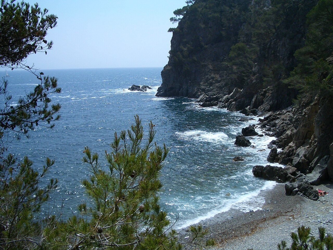
There is a restaurant at Cala Pedrosa. There is no road to Cala Pedrosa. Every crate of tomatoes, every gas bottle, every case of beer that ends up on that terrace has either walked down a cliff path or arrived by boat, and so has everything that comes back up as rubbish. It is worth holding that in mind when you look at the prices, and worth knowing that the place shuts on Wednesdays and disappears entirely out of season. This is a cove where the most interesting thing is not the swimming — it is the logistics.
A Restaurant Nothing Can Drive To
The building is an old fishermen’s barraca, one of two still standing at the cove, converted into a small kitchen and a handful of outdoor tables at the water’s edge. It is run by a couple of women, and what comes out of it is unfussy and cooked in front of you: fresh fish of the day, tortilla, salads, charcuterie, rice and fideuà cooked in the open air.
Expectations are the thing to get right. This is not a destination restaurant and nobody involved is pretending it is. It is simple food at a difficult address, priced accordingly, and the fair way to judge it is against the alternative — which is a cereal bar in your rucksack after a forty-five-minute walk.
Two practical points. It closes on Wednesdays and does not operate outside the season, so a walk planned around lunch can end with a locked door. And it is a small operation at the bottom of a cliff — take cash rather than assume the card machine has signal.
What the Cove Is Like
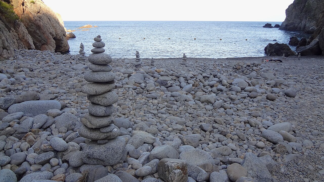
Tiny — reported at somewhere between 27 and 33 metres long, which is to say the size of a swimming pool. Pedrosa means rocky and the name is not decorative: the shore is large granite cobbles, not sand. Lying down takes a mat and a bit of arranging, and walking across it in flip-flops is how people turn ankles.
What you get in return is water. It is exceptionally clear over a rock bottom, sheltered, and with no motorised craft permitted, which is why people carry masks down here rather than towels. Sea urchins live on the rocks at the edges — water shoes are the sensible answer, going in and coming out.
Pine-covered cliffs close the cove on both sides, and there is no lifeguard, no toilet, no shower and no shade beyond what the rock gives you. The two barracas at the back are the only structures, and one of them is the kitchen.
The Park It Is Not In
A correction, because this one is copied around freely: you will read that Cala Pedrosa sits inside the Montgrí, Illes Medes i Baix Ter natural park. It does not. That park protects the coast around Torroella de Montgrí and l’Estartit, well to the north of here.
The confusion has an obvious source: there is a second Cala Pedrosa near l’Estartit, and that one is inside the park. “Rocky cove” is not an imaginative name and this coast has more than one. If you are looking up conditions, closures or protection rules, make sure the page you are reading is about the Palafrugell one, between Tamariu and Llafranc.
How to Get to Cala Pedrosa
On Foot from Tamariu
The easier of the two walks, at roughly thirty to forty-five minutes. Take the stairs at the southern end of Tamariu beach, past the diving platform they install for the summer, and follow the camí de ronda south. It alternates flights of steps, level sandy sections and stretches where you are walking over larger rock; the final descent into the cove is the steepest part and has a wooden handrail.
On Foot from the Sant Sebastià Lighthouse
The longer, higher route: the path leaves from beside the lighthouse restaurant — the headland behind it carries 2,600 years of occupation and is worth an hour in its own right, as set out below — and follows the GR-92 waymarks along the clifftop before turning inland through dense Mediterranean woodland and dropping to the cove. About forty-five minutes, with roughly 165 metres of descent.
Palafrugell’s own tourist information is blunt about this one: it recommends the route for walkers used to mountain terrain, and warns to take particular care on the first stretch, which passes close to unprotected cliff edges. Take that at face value.
By Boat
Small boats and kayaks anchor off the cove routinely, and it is the only way to arrive without walking. It is also how a good deal of the restaurant’s supplies get in.
Map
There is no road access, so the map may centre on the cove or on Tamariu, where the main approach begins.
The Headland You Set Off From
If you take the lighthouse route, do not treat the top as a car park. The Conjunt Monumental de Sant Sebastià de la Guarda is the record of people choosing the same 165-metre clifftop over and over again for at least 2,600 years, and four separate periods are visible on it at once.
- The Iberian settlement, occupied from the second half of the 6th century BC. It was consolidated and signposted in recent years, so there is something to look at rather than a field with a plaque. It was abandoned gradually during the 1st century BC — at exactly the moment a small Roman nucleus was starting up beside the beach at Llafranc, down below. People did not leave the area; they moved down to the water.
- The watchtower, 15th century, and listed as a Bé Cultural d’Interès Nacional — the top category of Catalan heritage protection. Three storeys and a roof terrace, rectangular merlons, arrow slits, built to watch for the corsair raids that were a routine fact of the 15th and 16th centuries here. Its plan is irregular, and the reason is that the chapel came first in the paperwork: the use of a tower here as a chapel was authorised in 1441, and the licence to build the tower itself followed in 1445. Hence the semicircular apse on the east side and the straight wall on the west. You can go up it, and it is the best thing on the headland.
- The chapel and the hostelry, 18th century. They exist because of a vow. After the plague of 1650 the people of Palafrugell promised to build here, and the complex went up in the early part of the following century to expand the space for worship and for pilgrims. The hostelry is a hotel now — it is the one with the terrace you walk under.
- The lighthouse, inaugurated in 1857 and the most powerful on the Catalan coast, throwing its light some 32 nautical miles — around 60 kilometres.
The view is the reason for all of it, and it still works: Llafranc immediately below, Calella de Palafrugell beyond, Cap Roig running out into the sea to the south-west, Cap de Begur to the north-east, and on a clear day the Pyrenees behind Palafrugell inland.
Which is the argument for doing the walk in this direction rather than the other. An hour on the headland first, then down to the cove — the history at the top and the swim at the bottom, in that order.
Eating and Sleeping Nearby
Beyond the barraca there is nothing at the cove, so carry water regardless of your lunch plans. Tamariu and Llafranc both have proper restaurant scenes within a short walk or drive, and there is a well-regarded Japanese restaurant up at the Sant Sebastià lighthouse with one of the best positions on the coast.
For a base, Tamariu is the smaller and quieter of the two villages and puts the Pedrosa path at the end of its beach; Llafranc is larger and better connected. Palafrugell town, a few kilometres inland, has the widest choice and the market. Walking south from here the camí de ronda eventually reaches Cala Estreta and Platja de Castell, which is a serious day out rather than an afternoon.
When to Go
The thing to plan here is not the arrival but the return. Both walking routes are pleasant in one direction and tiring in the other, and the classic version — down from the Sant Sebastià lighthouse and on to Tamariu — is downhill almost the whole way, which leaves you three and a half kilometres from your car at the top of a hill.
In summer that is solved by the Moventis bus back from Llafranc. The rest of the year it is a taxi, which has been running at around €25 for the twelve-minute drive. Decide which of those you are doing before you set off, not at the end of the day with tired legs.
By season: June and September give the warmest water with the path quiet. Spring and autumn are the best walking, with the woodland sections at their best and no heat on the exposed clifftop. July and August work early in the day; the roadside parking at both trailheads is limited and goes first thing. In winter the cove is empty and the barraca is shut.
For how Cala Pedrosa compares with the rest of the region, see our Costa Brava beach rankings.
Practical Tips
- Not on a Wednesday if you want lunch. The barraca closes that day and out of season entirely.
- Water shoes, not flip-flops. Granite cobbles underfoot and sea urchins on the rocks at the edges.
- Sort out the way back first. Summer bus from Llafranc, taxi at around €25 the rest of the year.
- Take cash. Small operation, bottom of a cliff, no guarantee of signal.
- Respect the cliff warning on the lighthouse route. The council flags unprotected edges on the first section for a reason.
Frequently Asked Questions
Is there really a restaurant at Cala Pedrosa?
Yes — a converted fishermen’s barraca with outdoor tables, serving fish of the day, tortilla, salads and rice dishes. It closes on Wednesdays and outside the season.
Can you drive to Cala Pedrosa?
No. Park in Tamariu or near the Sant Sebastià lighthouse and walk in, or arrive by boat.
Is it inside the Montgrí, Illes Medes i Baix Ter natural park?
No. That is a different Cala Pedrosa, near l’Estartit. This one is at Palafrugell, between Tamariu and Llafranc.
Is it a sandy beach?
No — large granite cobbles. Bring something to lie on and something to walk in.
Written for general information, not as travel, legal or safety advice. Cala Pedrosa has no lifeguard, no toilets, no drinking water and no road access, and the shore is loose granite cobble. The approach from the Sant Sebastià lighthouse follows the GR-92 and passes close to unprotected cliff edges on its first section; Palafrugell’s tourist information recommends it for walkers accustomed to mountain terrain. The barraca’s opening days and season, bus timetables and taxi fares change without notice. Confirm current details with the Ajuntament de Palafrugell before travelling.
Sources
- Sant Sebastià de la Guarda. Ajuntament de Palafrugell and the Museu del Suro, which manages the site, for the 2,600 years of occupation, the Iberian settlement of the 6th to 1st centuries BC, the 15th-century watchtower and its status as a Bé Cultural d’Interès Nacional, the 18th-century chapel and hostelry and the 19th-century lighthouse. The Generalitat de Catalunya’s museum register carries the same account. The authorisation of the tower’s use as a chapel in 1441, and the irregular plan that resulted from it, come from the town hall’s own description of the building.
- The tower’s dates, now reconciled. This guide previously said that the specific year 1445 sat awkwardly with the authorisation of chapel use in 1441, and declined to choose between them. They are not in conflict. They are different acts. On 13 September 1441 the curia of Girona granted the prior of Santa Anna de Barcelona, lord of the castle of Palafrugell, leave to establish a chapel dedicated to Sant Sebastià in a tower near the sea — the first documentary mention of the place, and the date the Ajuntament de Palafrugell gives for the authorisation of chapel use. The licence to build the tower was granted by the prior on 21 February 1445, which is where that year comes from. By 1452 the tower is referred to as standing, in the permit issued for the chapel of Sant Elm at Sant Feliu de Guíxols. One date we still cannot pin down is the year Queen Maria of Aragon licensed the collection of alms for the works, given variously as 1442 and 1444; the hermit charged with collecting them, Jaume Corbera, is named consistently. The detailed chronology comes from local historical work rather than from an archival source we have read ourselves.
- The camí de ronda exists because of a legal easement rather than municipal goodwill: article 27 of the Ley 22/1988 de Costas requires a six-metre strip along the shore to be kept permanently clear for public passage, extendable to twenty where the ground is difficult. Our guide to the camins de ronda sets that out in full.
- The warning on the lighthouse route — that it suits walkers used to mountain terrain, and that the first section passes close to unprotected cliff edges — is Palafrugell’s own tourist information, not our editorialising.
- The barraca’s opening days, bus timetables and taxi fares change without notice. The beach buses are real and documented. The Ajuntament de Palafrugell runs them for the third consecutive year in 2026, from 1 July to 31 August, operated by Moventis, at €2 a single journey with free travel for under-3s and integrated ATM Girona passes new this season. The Bus 30′ runs daily every half hour from 07:30, last departure 21:30, linking the plaça d’Europa and els Ametllers with Calella and Llafranc. The Bus 60′ runs Palafrugell–Llafranc–Tamariu and back, which is the one that matters for reaching this cove from the Tamariu side. Stops and timings are adjusted each season, so confirm before relying on them — but the service itself is not in doubt.
Image Credits
- Header image: Cala Pedrosa by EliziR, licensed under CC BY-SA 3.0, via Wikimedia Commons.
- In-article image: Cala Pedrosa, Tamariu by Isidro Jabato, licensed under CC BY-SA 4.0, via Wikimedia Commons.
Leave a Reply