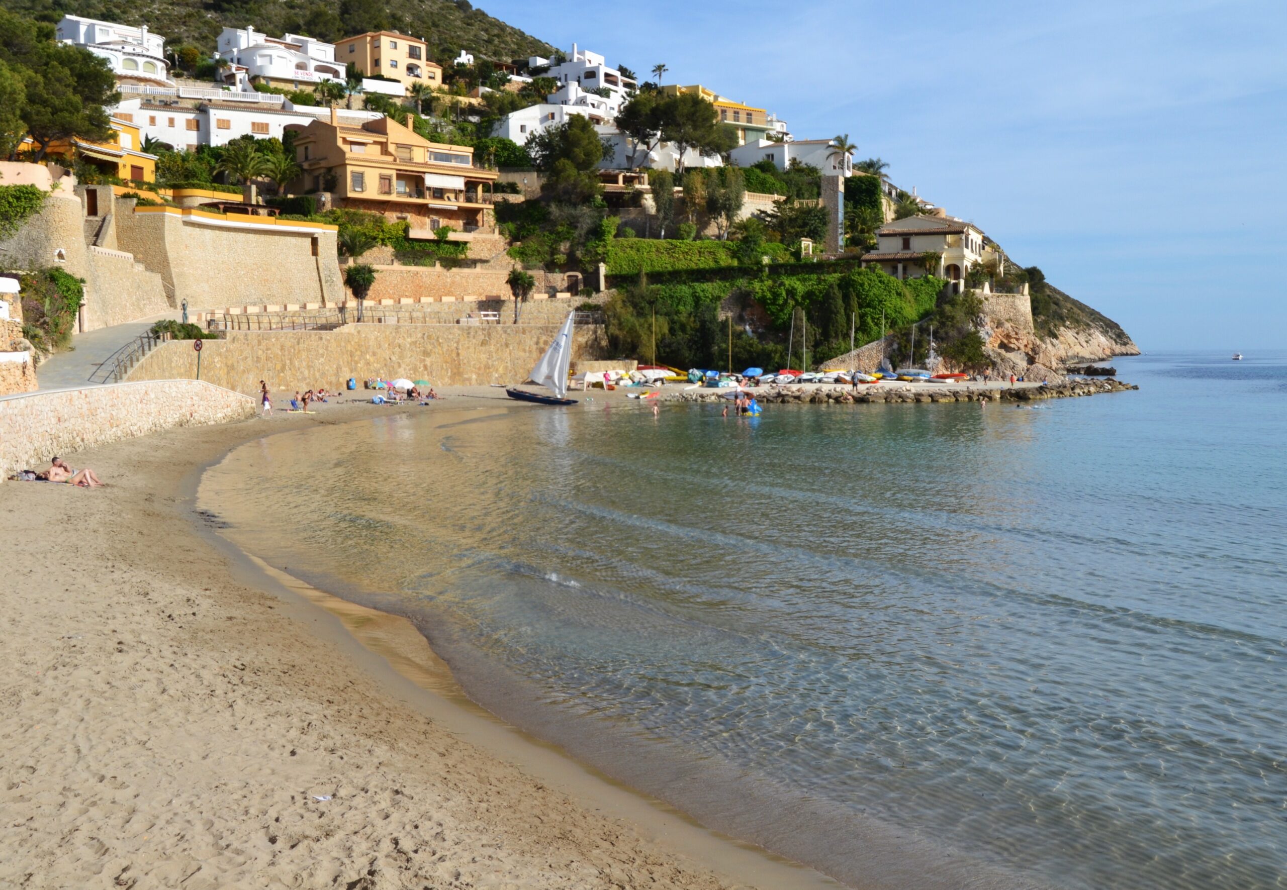
Almost every cove worth visiting on this stretch of the Marina Alta asks something of you first: a barrier that closes when the lot fills, a 300-metre concrete ramp, a path down a cliff. Cala de la Granadella and Cala del Moraig both do. El Portet asks nothing. You park, you walk twenty metres, and you are on actual sand — which on this coastline is rarer than it sounds.
That accessibility is the whole appeal, and also the whole problem in August. This guide covers what the cove is like, the 16th-century watchtower on the headland above it, how the parking works, and when to come if you would rather not lay your towel edge to edge with a stranger’s.
Where Is Cala el Portet?
Cala el Portet sits at the northern end of Moraira, a coastal town within the municipality of Teulada, in the province of Alicante — a couple of kilometres from Moraira’s centre along Avenida del Portet, a signposted coastal road that runs straight to the beach with no turns to worry about.
The Cap d’Or headland rises to the east, shielding the bay from wind and swell and giving it the shell-like curve that shows up in every photograph taken here.
What the Beach Is Actually Like
Fine, light-coloured sand — no water shoes needed, which sets El Portet apart from nearly every cove between here and Jávea. The bay runs somewhere between 280 and 350 metres depending on which source you trust, but only around 10 metres deep from shoreline to the built-up edge, and that narrowness matters more than the length: there is simply not much room.
The water is shallow near shore with a gentle slope, calm and clear thanks to Cap d’Or, and the seabed turns rocky toward the right-hand side of the cove as you face the sea. That rocky corner is where the snorkelling is — sargo, gilt-head bream, starfish, and a decent spread of marine plant life within a few metres of the shallows on a clear day. Kayaks and paddleboards rent directly from the sand, and the sheltered water makes paddling out around the headland straightforward even for beginners.
El Portet holds Blue Flag status, alongside Moraira’s other main beaches at l’Ampolla and Les Platgetes. It has adapted access, including walkways and amphibious bathing chairs, and Red Cross lifeguard cover in season. As an urban beach inside town limits, nudism is not permitted.
The Watchtower on Cap d’Or
The stone tower on the headland above the cove is not decorative. It went up in the second half of the 16th century, one link in a chain of watchtowers meant to give warning of Barbary raids. The chain exists because of a report: in 1563 the military engineer Giovanni Battista Antonelli surveyed the Valencian coast for Felipe II and set out where towers should stand. Construction here was ordered by the Duke of Maqueda, then viceroy of Valencia.
It sits at the highest point of the cape, around 165 metres above the sea and almost on the cliff edge. Circular, roughly seven metres across at the base and eleven high, solid stone for more than half its height, with battered masonry walls rendered in mortar and corbels at the top carrying a machicolation over the entrance side. There was only one way in: a rope ladder let down from inside. It also mounted two cannon covering the port of Moraira — and those cannon were found in 1980, on the sand at El Portet.
Its field of view runs from the Cap de la Nau in the north to the Peñón de Ifach in the south, and reaches the Serra Gelada on a clear day. The watch here signalled by lighting fires on the roof, passing warnings to the towers at Granadella, at Ambolo and at the Mascarat, and on to Ifach — and from there inland, which was the point. The corsairs were after the inland towns.
The Pirates Knocked It Down
The tower did not have a good century. Barbary raiders attacked it after 1563 and appear to have demolished most of it: an inspection by Acuña in 1585 records it as ruined, brought down by corsairs who had done the same to the towers at Les Caletes and La Bombarda. A watchtower built against pirates, destroyed by pirates, within a generation.
The other episode worth knowing happened on the beach you are lying on. In 1667 the tower’s watch went to the aid of a Neapolitan vessel, the San José y Santa Clara, attacked by two corsair ships. She ran for shelter into El Portet and was wrecked here. The crew were taken in and cared for by the authorities of Teulada.
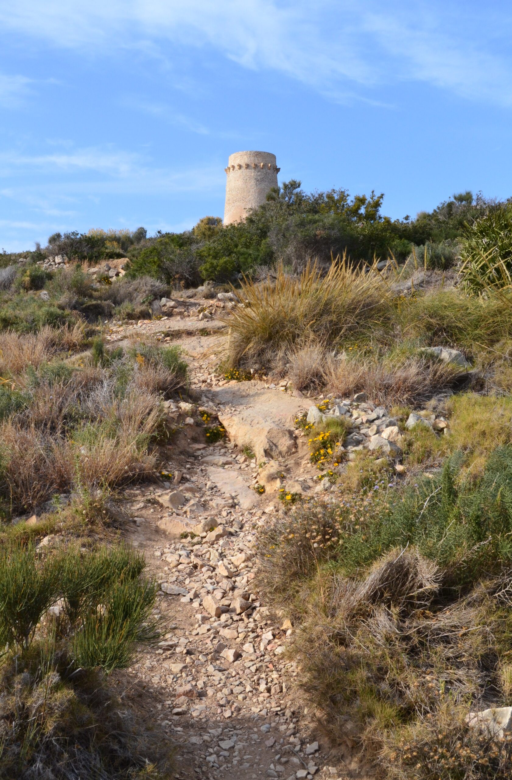
The walk up is genuinely easy: a signposted circular route of roughly a kilometre starting near the beach, about an hour round trip, manageable with children. The reward at the top is a view running the length of the coastline and out to the Peñón de Ifach.
The same history continues a short walk in the other direction, near Playa de l’Ampolla, where the Castillo de Moraira — a small fortress built around 1742 for the same purpose — was restored in the 1980s and now houses audiovisual exhibits on the area’s maritime and watchtower past.
Why Nobody Lived Here Until 1830
All of which explains something about this coast that is easy to miss when it is covered in villas.
The towers were not built to protect existing towns. They were built because the raiding was severe enough that towns could not establish themselves here at all. The botanist Cavanilles, surveying the Valencian kingdom, recorded that as late as 1779 there were still no settlements on this stretch. The castle at Moraira went up in 1742 to reinforce the defences and the coast stayed almost empty anyway.
What changed was not local. It was the French conquest of Algiers in 1830, which ended the corsair economy at its source. Only from that point did permanent settlements begin to take root in Teulada’s coastal strip, Moraira among them.
So Moraira is not an old fishing village that tourism found. It is barely two centuries old, and the reason it is not older is standing on the headland above the cove.
Getting There, and the Parking Problem
Leave the AP-7 at exit 63 (Benissa/Teulada) and follow the CV-743 into Moraira, then Avenida del Portet to the end. If you prefer a GPS pin, “Calle Puerto de Santa Cruz” lands you in the right place.
The lot beside the beach is free, unguarded, and holds somewhere between 50 and 100 cars. In July and August it is gone by mid-morning, and there is no barrier or booking system to tell you before you drive down — you simply arrive and find out. Before 10:00 AM is a realistic target in peak season. Failing that, the surrounding streets and a few restaurants that offer parking to customers are the fallback worth knowing about in advance rather than discovering at the bottom of the road.
No bus serves the beach directly, though intercity lines connect Moraira with Calpe and Teulada. Walking in from Moraira’s centre along the coastal promenade is pleasant and sidesteps the parking question entirely.
Eating and Staying Nearby
Three restaurants sit directly on the small seafront promenade — El Portet, Mañet, and Le Dauphin, which also turns up written as Dolphin — all Mediterranean, all with sea views. Le Dauphin works Mediterranean produce through French technique, which is less typical of this stretch of coast. Openings and hours change with the season. A pharmacy and a supermarket sit within about 500 metres.
The hills around the cove are villa territory rather than hotel territory, so most visitors staying nearby are in private rentals. Moraira’s centre, a few minutes away, has the hotels, apartments, restaurants, and the marina, and works well as a base for day trips to Cala del Portitxol and the wilder coves north toward Jávea.
When to Go
Water here follows the northern Costa Blanca curve: roughly 26–27°C at the August peak, low twenties through spring and autumn, dipping to around 14–17°C in winter. But nobody skips El Portet because the water is cold. They skip it because there is nowhere to put a towel.
| Period | What the cove feels like | Parking by mid-morning |
|---|---|---|
| April – May | Quiet enough to have stretches of sand to yourself; water still cold for long swims | Spaces available all day |
| June | Filling up but still comfortable; the best month for the Cap d’Or walk before the heat | Usually fine before midday |
| July – August | Towels edge to edge by late morning; the narrow strip works against you | Gone well before 10:00 AM |
| September | Warm water, thinning crowds — the sweet spot for most visitors | Manageable most days |
| October – March | Near-empty promenade, some restaurants on reduced hours | No competition at all |
Practical Tips
- Before 10:00 AM in July and August, or accept that you may be turning the car around.
- Go right for snorkelling. Facing the sea, the rocky side of the cove has the visibility and the fish; the open sand does not.
- Do the tower walk early or late. There is no shade on the route and it faces open sea.
- Know your backup parking before you drive down. The road ends at the beach, and turning around in August traffic is its own small ordeal.
- Consider walking in from Moraira along the promenade — it removes the problem entirely and takes about half an hour.
Frequently Asked Questions
Is Cala el Portet good for families with young children?
Yes — shallow, gently sloping water and real sand make it one of the more practical family beaches in the area, provided you arrive early enough to find space.
Can you visit the Cap d’Or tower itself?
The trail leads right up to it and the exterior is open to walkers. It is a protected historic structure, so treat it accordingly.
Restaurant openings, lifeguard cover, and rental services at El Portet are seasonal and change from year to year; the Ayuntamiento de Teulada is the authority to check against before relying on any of them. Nothing here is safety advice. The Cap d’Or trail runs close to cliff edges in places, and the rocky corner of the cove is slippery underfoot when wet.
Sources
Checked on 30 August 2026.
- The tower. The Ayuntamiento de Teulada-Moraira and the Generalitat Valenciana’s tourism record for the dating and purpose, and the Mancomunitat Cultural de la Marina Alta for the construction detail, the field of view from Cap de la Nau to the Peñón de Ifach, the chain of signalling towers and the 1667 rescue of the San José y Santa Clara. Spanish castles and fortifications are Bienes de Interés Cultural under the decree of 1949 and Ley 16/1985; this one included.
- A correction made in August 2026. This guide previously said the tower was built in 1563 to a design by Giovanni Battista Antonelli. That conflates two things. Antonelli’s 1563 report to Felipe II recommended where towers should be built along the Valencian coast; construction here was ordered by the Duke of Maqueda as viceroy of Valencia, and the sources place the building itself in the second half of the century rather than in 1563. The guide now says that.
- The destruction of the tower after 1563 rests on the inspection recorded by Acuña in 1585, which describes it as ruined and brought down by corsairs along with the towers at Les Caletes and La Bombarda.
- The settlement history. The absence of villages on this coast as late as 1779 is recorded by Cavanilles in his survey of the Kingdom of Valencia. The link between the French conquest of Algiers in 1830 and the founding of permanent settlements in Teulada’s coastal strip is the standard account of how Moraira came to exist.
- Beach services, lifeguard cover and parking are set by the Ayuntamiento de Teulada and revised annually. The published length of the cove varies between sources, which is why this guide gives a range.
- The Blue Flag. Administered in Spain by ADEAC, which publishes the list of awarded beaches (PDF). It is a voluntary certification the town hall applies for rather than a public designation, and the 2026 round runs for two years rather than one. Our guide to what the award measures sets out what it does and does not tell you.
- Two things fixed on 30 August 2026. This guide listed three restaurants on the promenade and then discussed a fourth, Le Dauphin, which is the same establishment as the Dolphin already named — so the paragraph implied more choice on that seafront than exists. It also credited one of them with a Tripadvisor Traveller’s Choice award in 2023, which we cannot source and which is not the kind of claim this site should be carrying about a named business in any case. Both are gone.
Image Credits
- Header image: La platja del Portet de Moraira by Joanbanjo, licensed under CC BY-SA 3.0, via Wikimedia Commons.
- In-article image: Sender i torre del cap d’Or, Moraira by Joanbanjo, licensed under CC BY-SA 4.0, via Wikimedia Commons.
Leave a Reply