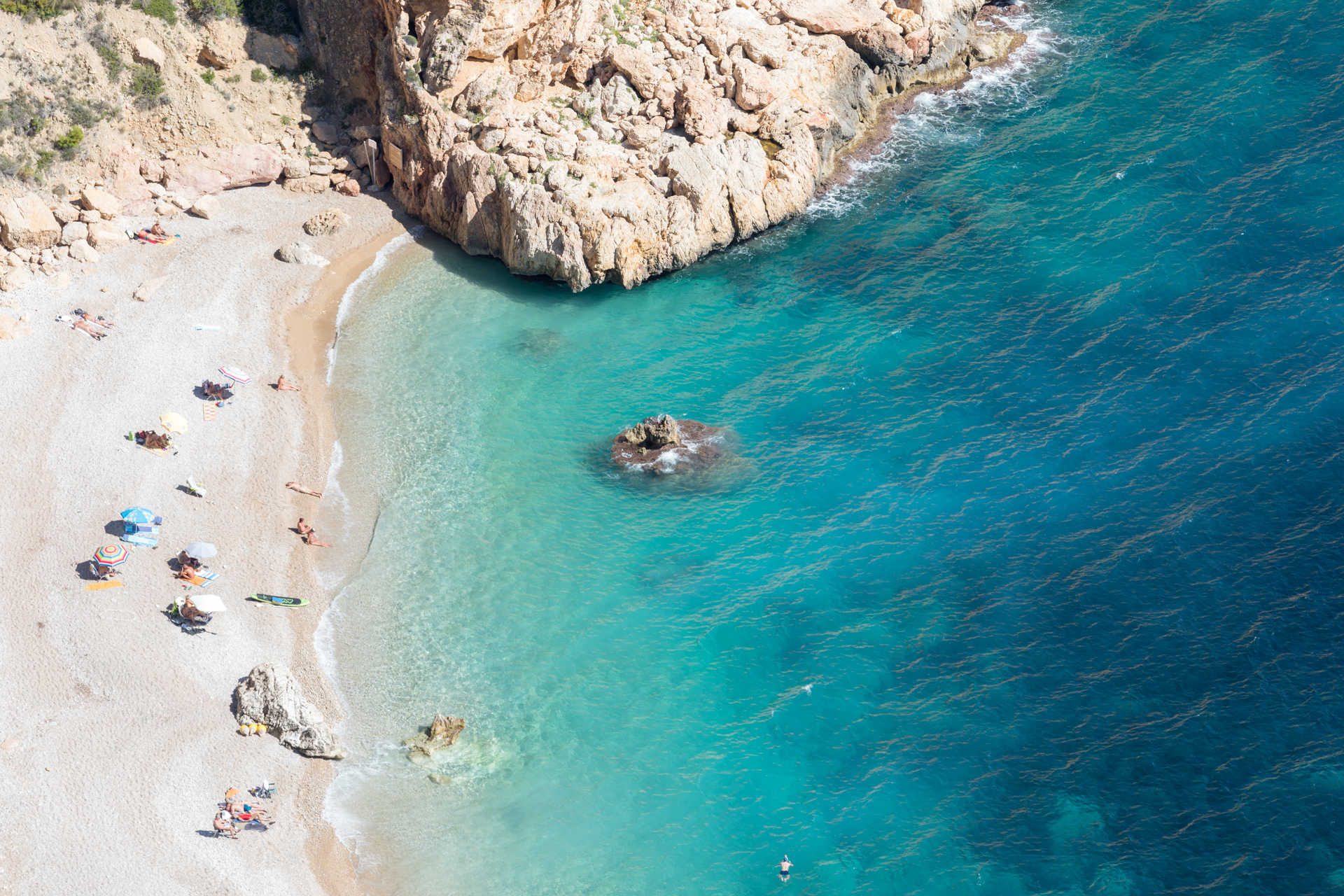
Hidden behind the Puig Llorença massif, between Moraira and Jávea, Cala del Moraig is the kind of beach you have to want to visit. There is no road that reaches the shoreline, no easy parking right next to the water, and no soft sand waiting for you when you arrive. What you get instead is one of the most striking coves on the entire Costa Blanca: crystalline turquoise water, dramatic limestone cliffs, a Blue Flag-certified shoreline, and access to one of the most famous sea caves in the province of Alicante, the Cova dels Arcs.
This guide walks through everything you need to know before heading to Cala del Moraig: what the cove is actually like, what there is to do both in and out of the water, how the (somewhat complicated) access and parking system works in 2026, where to eat and stay nearby, and when to go to avoid the worst of the crowds.
Where Is Cala del Moraig?
Cala del Moraig sits within the municipality of Poble Nou de Benitatxell (commonly shortened to Benitachell), on the Costa Blanca in the province of Alicante, roughly between the towns of Moraira and Jávea. The cove lies directly below the Cumbre del Sol residential development, tucked beneath cliffs that form part of the Puig Llorença massif.
It is widely considered the principal beach of Benitatxell and one of the most photographed coves in the entire Marina Alta region, frequently appearing on lists of the most beautiful beaches in Alicante and the Valencian Community as a whole.
What the Beach Is Actually Like
Cala del Moraig stretches around 200 to 300 meters in length, though only part of that distance is genuinely comfortable for swimming and sunbathing. The shoreline is made up of coarse gravel, pebbles, and rounded stones rather than sand, so closed-toe water shoes are highly recommended rather than optional.
What makes this cove genuinely unusual is its geology. Cala del Moraig actually has an artificial origin: part of the cliff face was blasted away decades ago during the construction of the nearby Cumbre del Sol urbanization, which is part of why the cove takes the brunt of winter storms despite its otherwise natural appearance today. The seabed is largely sandy with extensive Posidonia oceanica meadows, and the water is exceptionally clear, with visibility frequently reaching 10 to 20 meters on calm days, making this one of the best snorkeling and diving spots on this stretch of coast.
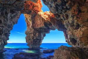
At the far end of the cove sits its most famous feature: the Cova dels Arcs, a sea cave that extends roughly 150 meters into the rock and is also the sea outlet of the longest underground river course in Spain, the Riu Blanc. Inside the cave, a freshwater spring creates a visible, shimmering layer over the saltwater below — a detail divers and snorkelers come specifically to see.
Things to Do at Cala del Moraig
Snorkeling and Scuba Diving
This is the main draw for most visitors. The combination of clear water, healthy Posidonia meadows, and rocky reef structure makes Cala del Moraig one of the best free-diving and snorkeling spots in the area, and the Cova dels Arcs in particular is a frequent destination for local diving operators exploring the cave system and its freshwater outlet.
Hiking the Ruta de los Acantilados (Cliff Route)
From the cove, the SL-CV 50 trail (known locally as the Ruta de los Acantilados) runs along the clifftops toward the wilder, harder-to-reach Cala de Llebeig, passing close to the geological formation known as the Falla del Moraig along the way. The full route involves roughly 300 meters of elevation change and rewards hikers with sweeping views from Cap d’Or to Cabo de la Nao.
Visiting the Falla del Moraig
A short, family-friendly path (around 20 minutes each way) branches off near the cove and leads to the Falla del Moraig, a striking geological fault exposing rock layers formed roughly 11 million years ago during the Upper Miocene. It is a Natural Monument, so rappelling and similar activities inside the fault require a permit, but the walk and viewpoint are open to everyone.
Kayaking and Paddleboarding
Renting a kayak or paddleboard, or arriving by one from a neighboring beach such as Cala de la Granadella, is a popular way to reach the small lagoon area near the Falla del Moraig and explore the coastline beyond what is reachable on foot. The same stretch of coast also connects, a little further north, with Cala del Portitxol and its well-known fishermen’s cottages.
Beach Characteristics at a Glance
- Type of shore: Coarse gravel, pebbles, and rounded stones (no sand)
- Length: Approximately 200–300 meters (roughly 200 meters suitable for swimming)
- Water: Calm in summer, exposed to winter storms; turquoise and highly transparent
- Seabed: Sandy with extensive Posidonia oceanica meadows
- Blue Flag status: Certified, including for the 2025 season
- Notable feature: Cova dels Arcs sea cave, roughly 150 meters deep
- Naturist area: A designated nudist area exists at the far (left) end of the cove
- Accessibility: Adapted access for people with reduced mobility, including an amphibious chair for bathing, though the final stretch down to the beach is on foot
How to Get to Cala del Moraig
By Car
From the AP-7 motorway, take the Ondara exit and follow the CV-741 toward Poble Nou de Benitatxell, then follow local signage for Cala del Moraig. The final stretch is a narrow, winding road of about 2 kilometers descending through the Cumbre del Sol development.
Important: there is no vehicle access directly to the beach. Cars must be left in the parking area at the top, and the final descent to the cove is made on foot, down a steep concrete ramp roughly 300 meters long. Pack light, since the walk back up is considerably harder than the walk down.
Parking and access fees (2026 season): Since 2023, the Ayuntamiento del Poble Nou de Benitatxell operates a reservation-based vehicle control system at Cala del Moraig, active from April 1 to October 15, between roughly 9:00 AM and 7:00–9:00 PM depending on the season. Visitors pay a flat daily fee (in the region of €12–15 per vehicle in recent seasons) regardless of how long they stay, though every vehicle gets a short grace period of around 20 minutes to enter and circulate without charge. Residents of Benitatxell who pay local vehicle tax can reserve a space free of charge, and a small number of spaces are reserved for people with reduced mobility. Booking a parking slot in advance through the official Cala Moraig website or app is strongly recommended in summer, since the lot fills quickly, often before 9:00 AM in August.
Shuttle Bus
A free shuttle bus runs several times a day from the village down to the cove and back, helping reduce car congestion on the access road during peak season. Schedules vary by year, so check current times with the town council before relying on it as your only option.
By Sea
Cala del Moraig is also reachable by kayak or paddleboard from neighboring coves, including Cala de la Granadella, for travelers who want to combine several beaches in a single day on the water.
Map
Where to Eat Near Cala del Moraig
There is a beach kiosk (chiringuito) at the cove itself for drinks and light snacks, but for a full meal most visitors head back up to Poble Nou de Benitatxell, where the village offers traditional Alicantine and Mediterranean restaurants, or onward to Moraira and Jávea, both a short drive away, which have a much wider selection of seafood restaurants and beachfront dining. Travelers continuing on to Cala el Portet in Moraira will find a similarly strong cluster of beachfront restaurants there.
Where to Stay Near Cala del Moraig
Most visitors stay in the Cumbre del Sol development itself, the residential area sitting directly above the cove, which offers apartments and villas within walking distance of the access path. Poble Nou de Benitatxell’s village center offers a quieter, more local base, while Moraira and Jávea, both within a short drive, provide a much broader range of hotels, resorts, and amenities for travelers who want more nightlife and services nearby.
Best Time of Year to Visit
Like most coves on this stretch of the Costa Blanca, summer brings the warmest water (around 27°C in August) but also the heaviest crowds, the tightest parking, and mandatory reservation fees. Given the steep walk down and back, visiting outside the hottest hours — early morning or from around 5:00 PM onward — is especially worthwhile here.
Outside the April–October vehicle control period, parking is free and far less competitive, making spring and late autumn appealing for visitors mainly interested in hiking the cliff route or photographing the Falla del Moraig rather than swimming. Winter water temperatures drop to around 16°C, and the cove can take a battering from storms given its exposed, artificially-formed shoreline.
| Month | Water Temp (approx.) | Crowd Level | Parking System |
|---|---|---|---|
| April–May | 18–20°C | Low–Moderate | Paid, reservation recommended |
| June | 22–24°C | Moderate | Paid, book in advance |
| July–August | 26–27°C | Very High | Paid, fills before 9:00 AM |
| September | 24–25°C | Moderate | Paid, reservation recommended |
| Oct 1–15 | 22–23°C | Low | Paid (last weeks of season) |
| Oct 16–March | 14–17°C | Very Low | Free, no reservation needed |
Services and Facilities
- Seasonal lifeguard, surveillance, and first-aid service
- Beach kiosk (chiringuito) for drinks and snacks
- Restrooms and foot-washing stations near the access point
- Walkways and an amphibious bathing chair for people with reduced mobility
- Reserved, paid parking with video surveillance
- Designated naturist area at the far end of the cove
Pets are not permitted on the beach, and camping is prohibited.
Practical Tips for Visiting Cala del Moraig
- Reserve your parking spot online in advance. Between April 1 and October 15, the lot operates on a booking system, and arriving without a reservation in peak summer is genuinely risky.
- Pack light for the walk down. The descent is a steep, roughly 300-meter concrete ramp, and you will need to climb back up the same way at the end of the day.
- Wear proper water shoes. The shoreline is coarse gravel and stones, and the rocks near the Cova dels Arcs can be slippery.
- Bring your own snorkel gear if you have it. The clear water and reef structure make this one of the better snorkeling spots in the area, but rental options at the cove itself are limited.
- Go early or late in the day during summer. This avoids both the midday heat on the exposed walk down and the worst of the crowds.
- Check the seasonal shuttle schedule with the Benitatxell town council if you would rather not walk down, or as a backup plan if parking is full.
Frequently Asked Questions
Can you drive directly to Cala del Moraig?
No. Vehicles must be left in the parking area at the top, and the final stretch down to the cove is on foot, via a steep paved path of roughly 300 meters.
Is Cala del Moraig good for snorkeling?
Yes. The combination of clear water, Posidonia oceanica meadows, and rocky terrain, including the Cova dels Arcs sea cave, makes it one of the better snorkeling and diving spots on this part of the Costa Blanca.
Does Cala del Moraig have a nudist area?
Yes, there is a designated naturist zone at the far end of the cove, on the opposite side from the main access point.
Is parking free at Cala del Moraig?
No, not during the regulated season. Between April 1 and October 15, parking requires a paid reservation. Outside that window, parking is free, though spaces are still limited.
This article is provided for general informational purposes only and does not constitute professional, legal, safety, or travel advice. Beach access rules, parking fees, reservation systems, and seasonal services can change without notice; always check official sources, including the Ayuntamiento del Poble Nou de Benitatxell, before planning your visit. Always follow posted safety guidance and lifeguard instructions where available, and use caution around sea caves and cliff areas.
Leave a Reply