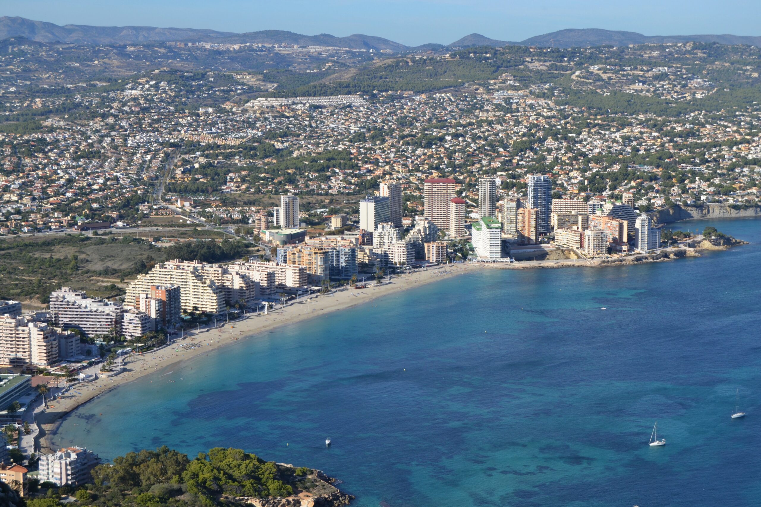
There is no getting around the rock. The Peñón de Ifach rises 332 metres straight out of the sea at the southern end of this beach, and it is in every photograph anyone has ever taken here, whether they wanted it or not. Playa de la Fossa is a kilometre of golden sand with a promenade, a floating platform, jet ski rental, and a 14th-century town buried at one end of it.
Where Is Playa de la Fossa?
Also called Playa de Levante, it sits in Calpe, province of Alicante, directly north of the Peñón. The bay runs between the rock and the Sierra de Toix, bordered at its far end by Playa de la Calalga and, past that, the protected Salinas de Calpe wetlands. This is the town’s main urban beach and its busiest.
For the opposite kind of day on the same stretch of coast, Playa Mascarat in neighbouring Altea trades all of this for a pebble cove under the Sierra de Bernia with nothing on it at all.
What the Beach Is Actually Like
Between 950 metres and a kilometre long, 40 to 50 metres wide depending on the section, fine golden sand throughout. The bay’s natural shelter keeps the water unusually flat — the comparison to a swimming pool comes up constantly and is not far off. Blue Flag, and the Spanish “Q” quality mark awarded by the Instituto para la Calidad Turística Española.
The beach is not uniform, though, and knowing that changes the visit. The central stretch, in front of the promenade, is where the crowds, the sunbeds, and the water sports concentrate. The southern end, where the sand narrows toward a small breakwater — locally the Cala de la Fossa — has clearer water, fewer people, and the only snorkelling on the beach worth the name, with the Peñón directly overhead.
One honest caveat: in the busiest weeks of summer, visitors regularly report seaweed accumulating and cleaning falling behind. It is a working urban beach in a resort town, not a protected cove.
The Medieval Town Under the Rock
Between the beach and the base of the Peñón lies something most visitors walk past without noticing: the Pobla medieval d’Ifach, a fortified town founded in the late 13th century by Roger de Llúria and abandoned within roughly a hundred years. It has been under archaeological excavation since 2005, and the walls, the church, and the layout of the streets are now visible on the ground.
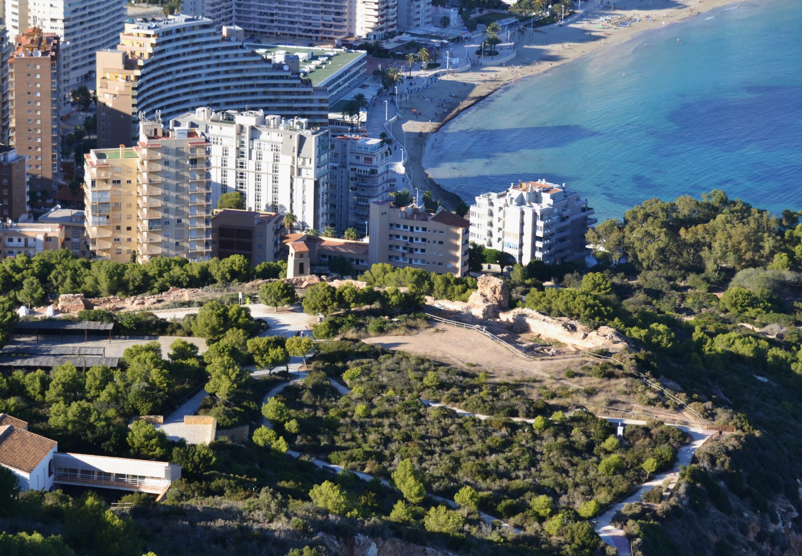
The site sits inside the Penyal d’Ifac natural park, and the trail to the summit passes it. The park was declared on 19 January 1987 — the first protected space of its kind in the province of Alicante — with 45 hectares, extended to 53.3 hectares on 2 April 2015. It is one of the smallest protected natural spaces in the Valencian Community and simultaneously one of the most visited, which is the tension that produced the rules below.
You Cannot Just Walk Up the Rock
This is the single thing most beach guides to Calpe get wrong, and getting it wrong costs you the day.
Since 2020, walking the Ruta Roja — the route from the visitor centre through the tunnel to the summit — requires a booking made in advance. There is a cap of 300 visitors per day on the summit path, set under the park’s Plan Rector de Uso y Gestión. Reservations are made online through the park’s own site, are personal and non-transferable, can be requested by an officer at any point, and can be made up to ten days ahead. Same-day booking is possible if places remain.
If you turn up without one and the 300 have not gone, an authorisation can be issued on the spot. If they have, you will not be going up. In July and August, assume they have.
Two things worth knowing before you book. The cap is a conservation measure, not a leftover from the pandemic — the park’s governing board had been raising the visitor-pressure problem since 2017, and the earlier rule limited how many people could be inside the park simultaneously before it was tightened to a daily quota. And the route is a genuine hike: around 4.6 kilometres, medium difficulty, and the final section has ropes anchored into the rock. The park advises against taking children beyond the tunnel because of the state of the path past that point.
Access to the park below the turnstile, and to the beach itself, is free and unrestricted during daylight. It is only the summit path that is capped.
Given all of which: if you are going to spend a day at this beach, book the rock several days ahead and walk it in the morning, before the heat and before the sand fills.
In and On the Water
A floating platform anchored offshore during the season is the beach’s most popular feature with children and teenagers. Kayaks, pedal boats, paddleboards, and jet skis rent directly from the sand, along with waterskiing and parasailing, and the flat water makes this a reasonable place to try any of them for the first time.
For snorkelling, go south to the breakwater end. Ca Iaio, near that stretch, has a local reputation for its rice dishes and is the natural stop afterwards.
In summer evenings the beach occasionally becomes an open-air cinema for children — an improvised, municipal sort of thing rather than a fixed programme, but a genuinely distinctive touch on this coast.
Getting There, Parking, and Services
By car, the beach is reached along Avenida de la Marina, signposted from the town centre and from both the AP-7 and the N-332. A large free public car park sits at one end. It fills on summer weekends and is comfortable on weekdays — which is, more broadly, the single most useful thing to know about this beach.
Buses connect Calpe with Benidorm, Altea, and the surrounding towns on seasonal schedules. Calpe’s train station is the nearest rail stop, from which a taxi or local bus finishes the trip.
On the beach itself: lifeguard cover, showers, restrooms and foot-washing points, wooden walkways over the sand, children’s play areas, a seasonal tourist information office on the promenade, and sunbed and umbrella rental at around €8–10 per item in recent seasons. An adapted bathing service operates on Calle Llevant near the Edificio Hipocampos from July 1 to September 30, with amphibious chairs, crutches, and adapted changing facilities — it requires an appointment booked in advance, so it is not something to turn up and hope for.
Eating and Staying
The promenade is solid restaurants, ice cream shops, bars, and pubs from one end to the other. This is not a beach where you need to plan a meal in advance.
It is also the most hotel-dense beach in Calpe, with a long line of beachfront hotels and apartments, many with direct sand access. That makes it a practical base for the Peñón, the Salinas wetlands, Calpe’s old quarter, and the coast south toward Altea.
When to Go
Water runs from around 14–17°C in winter to 26–27°C at the August peak. But on a beach this size with this many services, the temperature is rarely the deciding factor — the day of the week is.
| Period | Weekday | Weekend |
|---|---|---|
| April – May | Near-empty; the best window for the Peñón hike | Comfortable, easy parking |
| June | Pleasant, water sports already running | Busy but manageable |
| July – August | Noticeably calmer than most people expect | Packed, tight parking, cleaning under strain |
| September – October | Warm water, very few people | Moderate; arguably the best all-round time to come |
| November – March | Cold water, but the promenade and the rock are open and empty | |
Practical Tips
- Come on a weekday if you can. The difference at this beach between Tuesday and Saturday in August is larger than the difference between June and August.
- Head south for clear water. The breakwater end is quieter and the only part worth snorkelling.
- Book the adapted bathing service ahead. Appointment only, and only from July 1 to September 30.
- Book the Peñón before you travel. The summit path is capped at 300 people a day and needs an advance reservation. Do it up to ten days ahead, and walk it in the morning before the heat.
- Proper shoes for the rock. It is a 4.6-kilometre hike with ropes on the final section, not a stroll from the beach.
- Check sunbed prices before you sit down. Rates have climbed over recent seasons.
Frequently Asked Questions
Do I need a booking to see the medieval town at the foot of the Peñón?
No, and this is worth getting straight because guides to Calpe routinely muddle it. The Pobla d’Ifach and the lower part of the park are open during daylight with no reservation and no charge: you walk in past the visitor centre and the excavated streets, walls and church are there. What is capped is the Ruta Roja, the path from the tunnel up to the summit, limited to 300 people a day and requiring an advance booking through the park’s own site. So you can see the medieval town on a whim. You cannot climb the rock on one.
Sunbed pricing, the adapted bathing service, and access arrangements for the Penyal d’Ifac natural park are all set locally and change season to season; the Ayuntamiento de Calpe and the park office are the sources to check before travelling. The Peñón trail is a genuine hike with exposed sections and is not a stroll from the beach, whatever its proximity suggests.
Sources
Checked on 30 August 2026.
- The booking system and the daily cap. Generalitat Valenciana — official site of the Parc Natural del Penyal d’Ifac, which states the requirement to book the Ruta Roja in advance, that reservations are personal, non-transferable and may be demanded by an officer, and that they can be made up to ten days ahead. The 300-visitor daily quota on the summit path comes from the Régimen de Visitas of the park’s Plan Rector de Uso y Gestión, approved by Decreto 260/1993. Book through the park’s own site: reservations made anywhere else are not valid.
- The park itself. The park’s own description gives the current surface area of 53.3 hectares and describes it as simultaneously one of the smallest and one of the most visited protected spaces in the Valencian Community. It was declared on 19 January 1987, the first natural park in the province of Alicante, and the protected boundary was extended from the original 45 hectares on 2 April 2015.
- Why the cap exists. The Ayuntamiento de Calp’s account of the governing board’s decision is explicit that the measure is a conservation one and not a pandemic restriction, that the board had been raising visitor pressure since 2017, and that the earlier rule capped simultaneous presence inside the park before it was replaced by a daily quota.
- Beach services — lifeguard cover, sunbed pricing, the adapted bathing service and parking — are set by the Ayuntamiento de Calpe and revised annually. Confirm before travelling.
- The two certifications. The Blue Flag is administered in Spain by ADEAC, which publishes the list of awarded beaches (PDF); the 2026 round runs for two years rather than one, and our guide to what the award measures sets out what it does and does not tell you. The “Q” is a separate mark, awarded by the Instituto para la Calidad Turística Española to the beach’s management rather than to its water. We had described both as held consistently, which implies a run of years we have not checked; the guide now names them without that claim.
- Lifeguard cover, and a claim we have withdrawn. This guide said cover here runs year-round. Calpe does staff this beach for longer than most towns on the coast, but a twelve-month service would be unusual anywhere in Spain and we have not found it stated by the Ayuntamiento de Calpe. Since the consequence of being wrong is somebody swimming in February believing there is a lifeguard watching, the guide no longer says it. Cover, hours and season are municipal and revised annually; confirm before you rely on them.
Image Credits
- Header image: Platja de la Fossa des del penyal d’Ifac by Joanbanjo, licensed under CC BY-SA 3.0, via Wikimedia Commons.
- In-article image: Vista de la pobla d’Ifach des del penyal d’Ifac, Calp by Joanbanjo, licensed under CC BY-SA 3.0, via Wikimedia Commons.
Leave a Reply